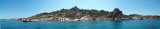
Golfo di Congianus is entered between Punta Capaccia and Capo Figari, 7.5 miles SE. Several islands and islets lie in its NW part and its shores are high, rocky, and indented. Secondaries bays of Conjanius gulf offer good anchorages (cala di Volpe, Cugnana gulf). Several small yacht marinas are situated within the gulf.
2012/09/14
Update
Joëlle
Le Golfe de Congianus s'étend entre la pointe Capacio et le cap Figari, à 7,5 MN au SE. Un certain nombre d'îles et îlots s'étendent à l'ouvert du golfe, les îles Poveri, Mortorio et Soffi. Ses rivages sont hauts, rocheux et découpés. Les baies secondaires du golfe de Congianus offrent de bons mouillages (anse de Volpe, golfe de Cugnana). Plusieurs petites marinas se trouvent dans le golfe.
2012/09/14
Update
Joëlle
Il Golfo di Congianus si estende tra la punta Capacio e il Capo Figari, 7.5MN to SE. Un certo numero di isole e isolotti si estendono all'apertura del Golfo, Isole Poveri, Mortorio e Soffi. Le sue rive sono alta e rocciosa. Le baie secondarie del Golfo di Congianus offrono buoni ancoraggi (cala di Volpe, Golfo di Cugnana). Diversi piccoli marina si trovano nel Golfo.
Tavolara island is a limestone massif 6 kilometres long and 500 m wide, and 565 m high.The overhanging cliffs make it inaccessible, with the exception of a bay and a beach that is located at each end of the island, Spalmatore di Fuori northeast (military zone) and Spalmatore di Terra ...
Degli Aranci gulf is is bounded, on the N, by the peninsula of which Capo Figari is the E extremity.This gulf is sheltered from NE and NW winds. Strong SE winds send in a heavy sea and storms from the N and E cause a considerable swell in the gulf. During offshore winds, which are ...
Gulf of Arzachena (Arsachena), located between Punta Saline and Tre Monti Cape, is a high inlet whose banks are lined with shoals. S tip, Arzachena, W of the entrance, a beacon consists of an iron post with a sheer spherical white marks a rock particularly ...
It is the largest island of the archipelago composed of sixty islets and 7 major islands, in the NE end tip of Sardinia. It is mountainous and arid. This is the only inhabited island thoroughly. It is connected by a bridge to Caprera island where are the house and the tomb of Garibaldi. ...
This gulf is S Cugnana gulf, S cala della Volpe. It is entered between Punta della Volpe and Punta Canigione.This gulf is the most protected area of the coast. Although the anchorage is prohibited in the Gulf because of submarine telegraph cables, many boaters anchor in this ...


 Golfo di Congianus is entered between Punta Capaccia and Capo Figari, 7.5 miles SE. Several islands and islets lie in its NW part and its shores are high, rocky, and indented. Secondaries bays of Conjanius gulf offer good anchorages (cala di Volpe, Cugnana gulf). Several small yacht marinas are situated within the gulf.
 Le Golfe de Congianus s'étend entre la pointe Capacio et le cap Figari, à 7,5 MN au SE. Un certain nombre d'îles et îlots s'étendent à l'ouvert du golfe, les îles Poveri, Mortorio et Soffi. Ses rivages sont hauts, rocheux et découpés.
 Il Golfo di Congianus si estende tra la punta Capacio e il Capo Figari, 7.5MN to SE. Un certo numero di isole e isolotti si estendono all'apertura del Golfo, Isole Poveri, Mortorio e Soffi. Le sue rive sono alta e rocciosa.