Isola di Mortorio (Sardegna)

Isola di Mortorio (Sardegna)

To precisely geolocate this site. Update if necessary.

Localisation

Isola di Mortorio (Sardegna)
LatitudeLongitude
DMS------
DM------
DD------

Characteristics

Island / Atoll
Mooring
Beach
Sand
Natural Park

Description

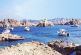
Mortorio island, near Cala di Volpe, is a privately-owned uninhabited. It is part of the Archipelago of La Maddalena.

Naked island surrounded by rocks, emerged and submerged. It offers 3 bays frequented in summer.

Many birds nest on the island, would safeguard by the institution of the International Park of the Strait of Bonifacio, which the island belongs.

Be careful if you want to anchorare the night, no need to be sensitive to the cries of birds that become awesome!

history


In the eighteenth century, they found human remains from a naval battle between the inhabitants of Pisa and those of Gene to obtain the domination of N Sardinia.


2012/09/18
Update
Joëlle
Isola di Mortorio (Sardegna)
2012-09-18
Update
Joëlle
L'île de Mortorio, à proximité de La Cala di Volpe, est une propriété privée inhabitée. Elle fait partie de l'Archipel de la Maddalena.

Île nue et découpée entourée de roches émergées et immergées. Elle offre 3 criques très fréquentées en été.

De nombreux oiseaux nichent sur l'ile, protégés par l'institution du parc international des Bouches de Bonifacio, dont l'île fait partie.

Attention si vous comptez rester à l'ancre la nuit, il ne faut pas être sensible aux cris d'oiseaux qui deviennent alors impressionnant!


Histoire


Au XVIII ème siècle, on y trouva des restes humains provenant d'une bataille navale entre les habitants de Pise et ceux de Gène, afin d'obtenir la domination du N de la Sardaigne.


2012/09/18
Update
Joëlle
L'isola di Mortorio, vicino a La Cala di Volpe, è una proprietà privata disabitata. Fa parte dell'Arcipelago di La Maddalena.

Isola nuda circondata da rocce, emersa e sommersa. Offre 3 baie estiva.

Numerosi uccelli nidificano sull'isola, salvaguardi dall'istituzione del parco Internazionale delle Bocche di Bonifacio, del quale l'isola fa parte.

Attenzione se volete anchorare la note, non bisogno essere sensibile ai gridi degli ucelli che diventano alora impressionante!


Storia

Nel XVIII secolo, hanno trovato resti umani di una battaglia navale tra gli abitanti di Pisa e quelli del gene per ottenere il dominio di N della Sardegna.

2012/09/17
Update
Joëlle
Ebook

Sardegna North East

  • 156 sites
  • 349 photos
  • publication date: 11 Jul 2023
  • .pdf file size: 66 Mb
Isola di Mortorio (Sardegna)
2012-09-18
Update
Joëlle
Share your comments or photos on "Isola di Mortorio (Sardegna)"

Sites around Isola di Mortorio (Sardegna)

Flying distances - Direct line

Isola Tavolara (Sardegna)

11nm
155°
Tavolara island is a limestone massif 6 kilometres long and 500 m wide, and 565 m high.The overhanging cliffs make it inaccessible, with the exception of a bay and a beach that is located at each end of the island, Spalmatore di Fuori northeast (military zone) and Spalmatore di Terra ...
7 May 14
Joëlle

Golfo degli Aranci (Sardegna)

5.5nm
171°
Degli Aranci gulf is is bounded, on the N, by the peninsula of which Capo Figari is the E extremity.This gulf is sheltered from NE and NW winds. Strong SE winds send in a heavy sea and storms from the N and E cause a considerable swell in the gulf. During offshore winds, which are ...
28 Sep 12
Joëlle

Golfo Di Arzachena (Sardegna)

7.6nm
294°
Gulf of Arzachena (Arsachena), located between Punta Saline and Tre Monti Cape, is a high inlet whose banks are lined with shoals.
S tip, Arzachena, W of the entrance, a beacon consists of an iron post with a sheer spherical white marks a rock particularly ...
8 Sep 12
Joëlle

Isola La Maddalena (Arcipelago della Maddalena)

12nm
316°
It is the largest island of the archipelago composed of sixty islets and 7 major islands, in the NE end tip of Sardinia. It is mountainous and arid. This is the only inhabited island thoroughly.
It is connected by a bridge to Caprera island where are the house and the tomb of Garibaldi. ...
26 Nov 12
Joëlle

Golfo di Marinella (Sardegna)

3.9nm
203°
This gulf is S Cugnana gulf, S cala della Volpe. It is entered between Punta della Volpe and Punta Canigione.This gulf is the most protected area of the coast. Although the anchorage is prohibited in the Gulf because of submarine telegraph cables, many boaters anchor in this ...
23 Sep 12
Joëlle

Cala NE di Mortorio (Sardegna)

0.2nm
198°
On the N, the cove has a good shelter, from NE to W by the S.Beware to a shoal on port side. Anchor in 5 to 21 m.
17 Sep 12
Joëlle