Le golfe de Spurlatta se trouve au SE du cap Ceraso et s'étend jusqu'au cap Coda Cavallo. L'île de Tavolara, située à 4,2 MN du cap Ceraso, constitue l'extrémité N du golfe.
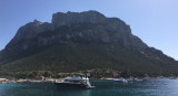
Tavolara island is a limestone massif 6 kilometres long and 500 m wide, and 565 m high.The overhanging cliffs make it inaccessible, with the exception of a bay and a beach that is located at each end of the island, Spalmatore di Fuori northeast (military zone) and Spalmatore di Terra ...
Degli Aranci gulf is is bounded, on the N, by the peninsula of which Capo Figari is the E extremity.This gulf is sheltered from NE and NW winds. Strong SE winds send in a heavy sea and storms from the N and E cause a considerable swell in the gulf. During offshore winds, which are ...
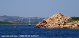
Isola Molara, private island, S Tavolara island, 158m high, is undulating and partially cultivated.The coasts are high and rocky at E (Punta Levante et Punta di Sirocco), they are more practicable with the few beaches and coves located in NW (Cala Cala Chiesa e Spagnola).We see a ...
Spalmadore di Terra, a bight, lies at the SW end of Isola Tavolara and offers anchorage, in a depth of 20m, about midway between the entrance points. This berth is exposed to SE winds which send in a heavy sea. Several houses stand at the head of the bight and a conspicuous ...


")
")
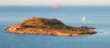
 Golfo Spurlatta entered SE of Capo Ceraso, and lies up to Coda Cavallo cape. Tavolara island, located 4,2 NM of Ceraso cape, is the N end of the gulf.
 Le golfe de Spurlatta se trouve au SE du cap Ceraso et s'étend jusqu'au cap Coda Cavallo. L'île de Tavolara, située à 4,2 MN du cap Ceraso, constitue l'extrémité N du golfe.