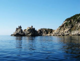
Capo Ferrato, a steep and whitish promontory, 51 m, rises to Monte Ferru, 299m high and fall steeply on the sea. This conical hill stands 1.5 miles inland and is surmounted by a prominent white, tower, 10 m high.
2012/10/13
Update
Joëlle
Capo Ferrato, situé sur un promontoire escarpé et rocheux, à 51 m du niveau de la mer, tombe à pic sur la mer. Le cap porte un phare, tour blanche haute de 10 m, adossée à une maison blanche.
2012/10/13
Update
Joëlle
Capo Ferrato, situato su un promontorio a picco e biancastro, 51 m dello nivelo della mare, scende ripidamente sulla mare. Il capo ha un faro, torre bianca di 10 m di altezza, sostenuta da una casa bianca.
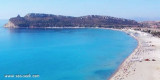
Quartu gulf lies between Foxi tower and S. Elia cape, in the Cagliari Gulf.It is not recommended to anchor in the Quartu bay.Ancorage is also prohibited in a strip between the bearings to 314 ° of Mezza Spiaggia tower and 316 ° to the S. Elia E end cape and extending to 7 NM of shore.
Carbonara gulf is located between Carbonara cape and Boi cape, in the Cagliari gulf, on its E side.Depending on the wind,we anchor on the W or E side of the bay. This large bay, rock and sand bottom, is very pretty and very crowded in summer. NW of Carbonara cape, Carbonara Bay ...
A little off Turno Mount is S. Elmo rock, some hundred meters from the coast, less than 20 m deep. This rock has the particularity of having, below the level of the sea, a small cave that can be explored by divers.
Serpentara island is 1,7 NM off the coast. It is flat and bare and N is extended by a shoal which emerge 3 large rocks. You can anchor between the island and the earth, at 1 NM SSW Cala Pira tower.


")
 Capo Ferrato, a steep and whitish promontory, 51 m, rises to Monte Ferru, 299m high and fall steeply on the sea. This conical hill stands 1.5 miles inland and is surmounted by a prominent white, tower, 10 m high.
 Capo Ferrato, situé sur un promontoire escarpé et rocheux, à 51 m du niveau de la mer, tombe à pic sur la mer. Le cap porte un phare, tour blanche haute de 10 m, adossée à une maison blanche.
 Capo Ferrato, situato su un promontorio a picco e biancastro, 51 m dello nivelo della mare, scende ripidamente sulla mare. Il capo ha un faro, torre bianca di 10 m di altezza, sostenuta da una casa bianca.
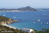
") Capo Ferrato vu du Nord
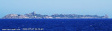
Capo Ferrato vu du Nord") Capo Ferrato vu du S
Capo Ferrato vu du S