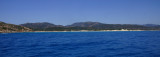
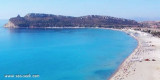
Between Spartivento cape and Pula cape, the coast is lined, with the exception of a short stretch, by a sandy beach very clear.. Near the cape the Guideo islet is projected on clear sandy dunes.
2012/10/19
Update
Joëlle
Le cap Pula est débordé à l'E par le rocher Coltellazo.
Entre le cap de Pula et le cap Spartivento, la côte est bordée, à l'exception d'un court tronçon, d'une plage de sable très clair. Près du cap l'îlot Guideo se projette sur des dunes de sable très clair.
2012/10/19
Update
Joëlle
Capo Pula E è sopraffatto dallo scglio Coltellazo.
Tra il capo di Pula e il capo Spartivento, la costa è rivestita, con l'eccezione di un breve tratto da una spiaggia di sabbia chiara. Vicino al capo l'isolotto Guideo si erge su dei dune di sabbia chiara.
Quartu gulf lies between Foxi tower and S. Elia cape, in the Cagliari Gulf.It is not recommended to anchor in the Quartu bay.Ancorage is also prohibited in a strip between the bearings to 314 ° of Mezza Spiaggia tower and 316 ° to the S. Elia E end cape and extending to 7 NM of shore.
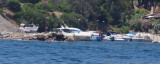
Small private harbour near S. Margherita di Pula.Beware if the sea is choppy with E winds or Sirocco, entry of port is difficult by the presence of shoals (E side and W side) unreported on the map.
It is advisable to keep the center of the channel to avoid the rocks side. T/fax: ...
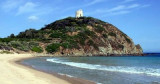
Chia tower was built on a promontory in 1639. The construction was part of the defensive network composed of the coastal towers, set up between the sixteenth and seventeenth centuries by the Crown of Spain against the incursions of the Barbary pirates. The Tower of Chia had two guns.
Cala Cipolla is just S of Chia bay and before Spartivento cape. An islet separated from the mainland by a narrow isthmus is an ideal base to anchor, even for the night.
It is well protected from the winds (NW and E) and offers good anchorage by 4/5 m.


 Pula cape is overwhelmed by Coltellazo rock.
 Le cap Pula est débordé à l'E par le rocher Coltellazo.
 Capo Pula E è sopraffatto dallo scglio Coltellazo.