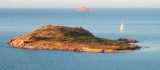
Point S of Olbia gulf, is the NE end of a promontory. A tower is located on the cape. A shoal extends beyond the cap and extends more than 0.4 NM E of it. A large rock is 0.2 NM E Cape and is indicated by a beacon.
An island located 0.1 NM NW of the cape is also marked by a beacon. This cape is the N limit of Natural Area marina protetta Tavolara - Punta Coda Cavallo.
2012/10/1
Update
Joëlle
Le point S du golfe d'Olbia, est l'extrémité NE d'un promontoire. Une tour se trouve sur le cap. Un haut-fond déborde ce cap et s'étend à plus de 0,4 MN à l'E de celui-ci. Un gros rocher se trouve à 0,2 MN à l'E du cap et est indiqué par une balise.
Un îlot situé à 0,1 MN au NW du cap est aussi marqué par une balise.
Ce cap représente la limite N de l'Area naturale marina protetta Tavolara - Punta Coda Cavallo.
2012/10/1
Update
Joëlle
Il punto S del Golfo di Olbia è la fine a NE di un promontorio. Una torre si trova sul promontorio. Uno banco si estende oltre il capo e si estende a più di 0,4 MN E di esso. Una granda roccia è da 0,2 MN all'E del Capo e è indicato da uno tag.
Un'isola situata 0,1 MN NW del promontorio è segnata anche da uno tag.
Il capo rappresenta il limite nord dell’Area naturale marina protetta Tavolara - Punta Coda Cavallo.
Tavolara island is a limestone massif 6 kilometres long and 500 m wide, and 565 m high.The overhanging cliffs make it inaccessible, with the exception of a bay and a beach that is located at each end of the island, Spalmatore di Fuori northeast (military zone) and Spalmatore di Terra ...
Degli Aranci gulf is is bounded, on the N, by the peninsula of which Capo Figari is the E extremity.This gulf is sheltered from NE and NW winds. Strong SE winds send in a heavy sea and storms from the N and E cause a considerable swell in the gulf. During offshore winds, which are ...
This gulf is S Cugnana gulf, S cala della Volpe. It is entered between Punta della Volpe and Punta Canigione.This gulf is the most protected area of the coast. Although the anchorage is prohibited in the Gulf because of submarine telegraph cables, many boaters anchor in this ...
Isola Molara, private island, S Tavolara island, 158m high, is undulating and partially cultivated.The coasts are high and rocky at E (Punta Levante et Punta di Sirocco), they are more practicable with the few beaches and coves located in NW (Cala Cala Chiesa e Spagnola).We see a ...
Gulf of Arzachena (Arsachena), located between Punta Saline and Tre Monti Cape, is a high inlet whose banks are lined with shoals. S tip, Arzachena, W of the entrance, a beacon consists of an iron post with a sheer spherical white marks a rock particularly ...


")
 Point S of Olbia gulf, is the NE end of a promontory. A tower is located on the cape. A shoal extends beyond the cap and extends more than 0.4 NM E of it.
 Le point S du golfe d'Olbia, est l'extrémité NE d'un promontoire. Une tour se trouve sur le cap. Un haut-fond déborde ce cap et s'étend à plus de 0,4 MN à l'E de celui-ci.
 Il punto S del Golfo di Olbia è la fine a NE di un promontorio. Una torre si trova sul promontorio. Uno banco si estende oltre il capo e si estende a più di 0,4 MN E di esso.