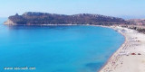
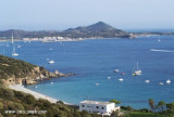
Carbonara gulf is located between Carbonara cape and Boi cape, in the Cagliari gulf, on its E side.Depending on the wind,we anchor on the W or E side of the bay. This large bay, rock and sand bottom, is very pretty and very crowded in summer. NW of Carbonara cape, Carbonara Bay ...
Quartu gulf lies between Foxi tower and S. Elia cape, in the Cagliari Gulf.It is not recommended to anchor in the Quartu bay.Ancorage is also prohibited in a strip between the bearings to 314 ° of Mezza Spiaggia tower and 316 ° to the S. Elia E end cape and extending to 7 NM of shore.
The shoal, W Cala Caterina, is covered by 5 m of water. It is marked at NE by a red buoy. It is a famous point for diving where you can see two modern anchors surrounded by a multitude of fishes, sponges, yellow and white and Posidonia.
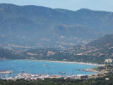
The marina is located on the west coast ofCarbonara cape (within the Marine Protected Area of Cape Carbonara) that we run along at a good distance. There are rocks around.
800 b. (<60 m) Tel:+39 070 7978006 Fax. +39 070 797137 Mail: info@marinavillasimius.it
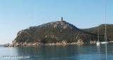
Porto Giunco bight is entered between Punta Molenti and Capo Carbonara. Giunco tower, partly in ruins,stands on the summit of a small promontory, 64m high, 1 mile N of Capo Carbonara.Anchorage can be taken, in a depth of 18m, sand and weed, about 0.7 mile ENE of this tower, between ...


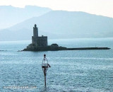
 Scoglio Santo Stefano lies about 0.2 mile SW of Fortezza Vecchio.
 Scoglio San Stefano se trouve à environ 0,2 MN au SW de la Fortezza Vecchio.
 Scoglio San Stefano si trova a circa 0,2 MN SW da Fortezza Vecchio.
")
")
")