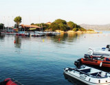
Located at bottom of the Gulf of Arzachana on the W shore, the port is composed of the former cement mole and floating pontoons.
T / F: 0789/88422
400 Berths
Depth: 1-4m
Maximum length: 25m
During the summer the port is busy, you land on the outside of the main mole, but only by a calm sea away from the shore due to the strong undertow.
Funds around Cannigione are poor holding, you must be given a lot of chain.
2012/09/8
Update
Joëlle
2012-09-08
Update
Joëlle
Situé au fond du golfe d'Arzachana sur la rive W, le port est constitué de l'ancien mole de ciment et de pontons flottants.
T./F: 0789/88422
400 places
Profondeur: 1-4m
Longueur maxi: 25m
Pendant la période estivale le port est très fréquenté, on accoster sur le externe du mole principal, mais seulement par mer calme en s'écartant du quai à cause du fort ressac.
Autour de Cannigione les fonds sont de tenue médiocre, il faut donner beaucoup de chaîne.
2012/09/8
Update
Joëlle
2012-09-08
Update
Joëlle
Situato nel fondo del Golfo di Arzachena, sulla riva W, il porto è costituito dall’antico molo di cemento e da pontili galleggianti.
T./F: 0789/88422
400 posti barca
Fondali: 1-4m
Lunghezza massima: 25m
In alta stagione il porto è spesso
affollato; ci si può ormeggiare anche sul lato esterno del molo
principale ma è consigliabile, anche in condizioni di mare calmo, tenere
la poppa ben discosta dalla banchina a causa della forte risacca.
Il
fondale intorno a Cannigione è un mediocre tenitore: occorre abbondare
in metri di catena.
Gulf of Arzachena (Arsachena), located between Punta Saline and Tre Monti Cape, is a high inlet whose banks are lined with shoals. S tip, Arzachena, W of the entrance, a beacon consists of an iron post with a sheer spherical white marks a rock particularly ...
It is the largest island of the archipelago composed of sixty islets and 7 major islands, in the NE end tip of Sardinia. It is mountainous and arid. This is the only inhabited island thoroughly. It is connected by a bridge to Caprera island where are the house and the tomb of Garibaldi. ...
Tavolara island is a limestone massif 6 kilometres long and 500 m wide, and 565 m high.The overhanging cliffs make it inaccessible, with the exception of a bay and a beach that is located at each end of the island, Spalmatore di Fuori northeast (military zone) and Spalmatore di Terra ...
Degli Aranci gulf is is bounded, on the N, by the peninsula of which Capo Figari is the E extremity.This gulf is sheltered from NE and NW winds. Strong SE winds send in a heavy sea and storms from the N and E cause a considerable swell in the gulf. During offshore winds, which are ...
La tourelle Pecorella marque l'entrée de ce golfe qui s'enfonce à plus de 4 M dans les terres. Celle de Chiapino qui était plus au S est démolie. Il faut donc remonter suffisamment vers le N pour ne pas risquer d'en toucher les restes. En piquant vers l'W, la balise noire délimite ...


 canal 11


 Located at bottom of the Gulf of Arzachana on the W shore, the port is composed of the former cement mole and floating pontoons.
")
 Situé au fond du golfe d'Arzachana sur la rive W, le port est constitué de l'ancien mole de ciment et de pontons flottants.
")
 Situato nel fondo del Golfo di Arzachena, sulla riva W, il porto è costituito dall’antico molo di cemento e da pontili galleggianti.
")