Cala Porteddu (Sardegna)

Cala Porteddu (Sardegna)

To precisely geolocate this site. Update if necessary.

Localisation

Cala Porteddu (Sardegna)
LatitudeLongitude
DMS------
DM------
DD------

Characteristics

Mooring
Beach
Sand
Rock
Windsurf

Description

Cala Porteddu (Sardegna)
2012-09-07
Update
Joëlle
Cala Porteddu (Sardegna)
2012-09-07
Update
Joëlle
Tiny cove located below Punta Arzachena. A small jetty is used by a sailing school based in land.

Beware to the reef marked by a beacon.

Anchor is also possible in the recess just below Punta Arzachena.
It is forbidden to anchor in the bay NW of Punta Arzachena.

TE 0.5 to 2 m
2012/09/8
Update
Joëlle
Crique minuscule située sous Punta Arzachena. Un petit ponton est utilisé par une école de voile basée à terre.

Attention au récif marqué par un fanion.

On peut mouiller aussi dans le renfoncement situé juste sous Punta Arzachena.
Il est interdit de mouiller dans la baie située au NW de Punta Arzachena.
  • TE 0,5 à 2 m
2012/09/7
Update
Joëlle
Minuscola insenatura che si trova a Punta Arzachena. Un piccolo molo è utilizzato da una scuola di vela basato a terra.

Attenzione alla secca caratterizzata da una bandiera.

Può anche ancorare nella cavità appena sotto Punta Arzachena.
E 'vietato ancorare nella baia situata al NW soto Punta Arzachena.


TE 0,5-2 m

2012/09/8
Update
Joëlle
Ebook

Sardegna North East

  • 156 sites
  • 349 photos
  • publication date: 11 Jul 2023
  • .pdf file size: 66 Mb
Share your comments or photos on "Cala Porteddu (Sardegna)"

Sites around Cala Porteddu (Sardegna)

Flying distances - Direct line

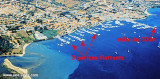
Golfo Di Arzachena (Sardegna)

0.4nm
91°
Gulf of Arzachena (Arsachena), located between Punta Saline and Tre Monti Cape, is a high inlet whose banks are lined with shoals.
S tip, Arzachena, W of the entrance, a beacon consists of an iron post with a sheer spherical white marks a rock particularly ...
8 Sep 12
Joëlle

Isola La Maddalena (Arcipelago della Maddalena)

6.3nm
345°
It is the largest island of the archipelago composed of sixty islets and 7 major islands, in the NE end tip of Sardinia. It is mountainous and arid. This is the only inhabited island thoroughly.
It is connected by a bridge to Caprera island where are the house and the tomb of Garibaldi. ...
26 Nov 12
Joëlle

Isola Tavolara (Sardegna)

17nm
137°
Tavolara island is a limestone massif 6 kilometres long and 500 m wide, and 565 m high.The overhanging cliffs make it inaccessible, with the exception of a bay and a beach that is located at each end of the island, Spalmatore di Fuori northeast (military zone) and Spalmatore di Terra ...
7 May 14
Joëlle

Golfe de Porto Vecchio

28nm
349°
La tourelle Pecorella marque l'entrée de ce golfe qui s'enfonce à plus de 4 M dans les terres. Celle de Chiapino qui était plus au S est démolie. Il faut donc remonter suffisamment vers le N pour ne pas risquer d'en toucher les restes.
En piquant vers l'W, la balise noire délimite ...
10 Jul 20
azerty

Cannigione (Sardegna)

1.3nm
180°
Located at bottom of the Gulf of Arzachana on the  W shore, the port is composed of the former  cement mole and floating pontoons.

T / F: 0789/88422400 BerthsDepth: 1-4mMaximum length: 25mDuring the summer the port is busy, you land on ...
8 Sep 12
Joëlle

Spiaggia Barca Bruciata (Sardegna)

0.9nm
327°
Large beach between Murra Point and La Barca Bruciata point. The bay offers good anchor during the day.
Near the beach, the promontory houses a campsite that offers many facilities including a jetty with a small dock.

Barca  Bruciata beach excellent shelter ...
7 Sep 12
Joëlle