Ramen Point ( Tamil Nadu-E India)

Ramen Point ( Tamil Nadu-E India)

Per individuare con precisione. Aggiornare se necessario.

Localizzazione

Caratteristica

Capo

Descrizione

Ramen Point ( Tamil Nadu-E India)
2012-03-20
Aggiornare
Jojo
Ramen Point is the E extremity of a narrow tongue of land projecting E from the coast.

A  temple in ruins lies about 183m W of the point; a coconut plantation lies about 183m farther W.

The coast from Ramen Point to Devipattanam, about 21 miles NW, is generally low and level.

Kathu Vallimuni Reef, consisting of scattered coral heads, extends up to 0.5 mile offshore, and lies parallel with the coast for about 1.8 miles W of Ramen Point.

There are several heads, which dry 0.6m, at the E end of the reef.

Vella Pertumuni Reef extends about 3 miles W of Kathu Vallimuni Reef, from which it is separated by a boat channel.

2012/03/23
Aggiornare
Jojo
Ebook

Bay of Bengal

  • 110 sites
  • 82 photos
  • publication date: 7 Jul 2023
  • .pdf file size: 53 Mb
Ramen Point ( Tamil Nadu-E India)
2012-03-23
Aggiornare
Jojo
Condividi i tuoi commenti o le foto su "Ramen Point ( Tamil Nadu-E India)"

Siti intorno a Ramen Point ( Tamil Nadu-E India)

Flying distances - Direct line

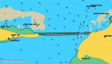
Pamban Pass (Tamil Nadu-E India)

0.5nm
101°
Pamban Pass is the navigable channel, partly artificial, through the banks which occupy the space between the W end of Pamban Island and the mainland.
It is of great advantage to coastal craft trading between ports on the W coast of India and ports of the Bay of Bengal.
A rocky ...
23 Mar 12
Jojo

Pamban port (Pamban Island-E India)

1nm
101°
Pamban, administered by a conservator, lies close N of the W extremity of Pamban Island. Cargo is handled by lighters to and from the beach.South and SW winds prevail from April to October.
23 Mar 12
Jojo

Pamban light (Pamban island-E India)

8.6nm
76°
Pamban Light is shown from a conspicuous white tower on a sandhill on the NW point of Pamban Island. NE Beacon, 5.5m high and white, lies close N of the light.
Kanthe Thuki Reef, composed of partly drying coral heads, lies between 0.3 and 0.5 mile W of Pamban Island Light.
A ...
23 Mar 12
Jojo

Kachchaitivu (Kachchtivu) island (Sri-Lanka)

21nm
72°
Kachchaitivu (Kachchtivu), about 10 miles SW of Delft Island , is 12m high and overed with scrub. There is a well and a small shrine on the NE side of the island.Depths of less than 9.1m extend 1 mile SE of the island.
Depths of less than 5.5m extend about 2.5 mile NE from the ...
23 Mar 12
Jojo

Dhanushkodi (Pamban island-E India)

14nm
113°
Dhanushkodi, about 2 miles NW of Lands End, is connected to the railway system of India.A pier, for use by vessels of the ferry service between Dhanushkodi and Talaimannar, extends from the NE coast of Pamban Island abreast the town. The pier is 219m long, with depths of 3.4m on each ...
23 Mar 12
Jojo

Lands End (Pamban island-E India)

16nm
116°
Lands End is the SE extremity of Pamban Island; a small but conspicuous building lies near the point.
Dhanushkodi, about 2 miles NW of Lands End, is a railroad terminal; the red-roofed railway buildings are conspicuous.
22 Mar 12
Jojo