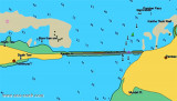

Lands End (Pamban island-E India)
2.5nm
137°
Dhanushkodi, about 2 miles NW of Lands End, is a railroad terminal; the red-roofed railway buildings are conspicuous.
22 Mar 12
Jojo
| Latitude | Longitude | |
| DMS | --- | --- |
| DM | --- | --- |
| DD | --- | --- |

 Dhanushkodi, about 2 miles NW of Lands End, is connected to the railway system of India.
A pier, for use by vessels of the ferry service between Dhanushkodi and Talaimannar, extends from the NE coast of Pamban Island abreast the town. The pier is 219m long, with depths of 3.4m on each side of the pier head; the pier carries a double railway track.
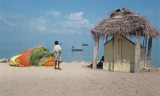
The town of Dhanushkodi is most known for a cyclone passing, in 1964,over the railway station and drowning 100 passengers in the train that was traveling.
Dhanushkodi was a small town only having a railway station, an hospital, some stores, and few houses. In 1964 a cyclone wiped out the whole town and a memorial was later created to those who died in the storm.
") remains of Dhanushkodi church
remains of Dhanushkodi churchEbook | Bay of Bengal
|