Pamban Light is shown from a conspicuous white tower on a sandhill on the NW point of Pamban Island. NE Beacon, 5.5m high and white, lies close N of the light.
Kanthe Thuki Reef, composed of partly drying coral heads, lies between 0.3 and 0.5 mile W of Pamban Island Light. A boat channel between this reef and the coast is used by pilots when boarding vessels during the Northeast Monsoon.
Outer Fairway Buoy, painted in black and white checkers, is moored in the N approach to Pamban Pass, about 0.3 mile NW of Kanthe Thuki Reef, and about 0.7 mile WNW of Pamban Island Light.
Kachchaitivu (Kachchtivu), about 10 miles SW of Delft Island , is 12m high and overed with scrub. There is a well and a small shrine on the NE side of the island.Depths of less than 9.1m extend 1 mile SE of the island. Depths of less than 5.5m extend about 2.5 mile NE from the ...
Pamban, administered by a conservator, lies close N of the W extremity of Pamban Island. Cargo is handled by lighters to and from the beach.South and SW winds prevail from April to October.
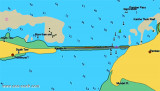
Pamban Pass is the navigable channel, partly artificial, through the banks which occupy the space between the W end of Pamban Island and the mainland. It is of great advantage to coastal craft trading between ports on the W coast of India and ports of the Bay of Bengal. A rocky ...
Ramen Point is the E extremity of a narrow tongue of land projecting E from the coast. A temple in ruins lies about 183m W of the point; a coconut plantation lies about 183m farther W. The coast from Ramen Point to Devipattanam, about 21 miles NW, is generally low and ...
Dhanushkodi, about 2 miles NW of Lands End, is connected to the railway system of India.A pier, for use by vessels of the ferry service between Dhanushkodi and Talaimannar, extends from the NE coast of Pamban Island abreast the town. The pier is 219m long, with depths of 3.4m on each ...
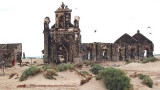
Lands End is the SE extremity of Pamban Island; a small but conspicuous building lies near the point. Dhanushkodi, about 2 miles NW of Lands End, is a railroad terminal; the red-roofed railway buildings are conspicuous.


 Pamban Light is shown from a conspicuous white tower on a sandhill on the NW point of Pamban Island. NE Beacon, 5.5m high and white, lies close N of the light.