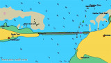
Pamban port (Pamban Island-E India)
0.4nm
107°
23 Mar 12
Jojo
| Latitude | Longitude | |
| DMS | --- | --- |
| DM | --- | --- |
| DD | --- | --- |

") Pamban bridge
Pamban bridgeEbook | Bay of Bengal
|
")
")
 Pamban Pass is the navigable channel, partly artificial, through the banks which occupy the space between the W end of Pamban Island and the mainland.
A rocky barrier extends in a straight line between the W coast of Pamban Island and Ramen Point, about 1.3 miles W.
Pamban Viaduct, which carries the South India Railway is built on this barrier.
A cutting, 61m wide, through the barrier and crossed by a rolling lift bridge, lies about 0.2 mile W of Pamban Island. The bridge is under the control of the Port Conservator at Pamban, who requires 30 minutes notice to open the bridge; in an emergency it can be opened immediately.
On the W side of Pamban Pass the barrier is named The Great Dam. It consists of large masses of flat-surfaced rocks, which were formerly portions of a causeway that extended from Pamban Island to the mainland. The N face of the dam is steep-to, and at LW presents a wall-like appearance, but the boulders are sufficiently separated to allow a free passage to the water.
The channel N of the rolling lift bridge over Pamban Pass is marked by buoys and beacons.
In 1979, it was reported that the maximum draft for vessels using the pass was limited to 2.1m.
The pass is used by some coastal vessels of from 200 to 800 grt and about 61m in length; these are as large as can safely transit the channel.
The tidal rise at Pamban Pass is 0.7m at MHWS, and 0.5m at MHWN.
The pass is well-marked with beacons, buoys, and is easy to navigate.
Tidal currents are only noticeable at the change of the monsoon in March, April, and October. At other times they are masked by the S current during the Northeast Monsoon, and by the N current during the Southwest Monsoon. These currents often attain velocities of 6 knots, making passage of the pass difficult.
Pilotage is compulsory for merchant vessels. Licensed pilots at Pamban are under the orders of the Pamban Port Conservator. Pilots are stationed at Kundagal (Kundugal) Point, the SW extremity of Pamban Island, Mundel Point at the W end of Pamban Island, and on the N side of Pamban Pass, to look out for vessels approaching Pamban.
There are no official signals for vessels needing a pilot, but local craft usually display a red or white flag.