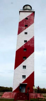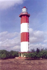
False Divi Point (E India)
It is located at the apex of the Krishna River delta and covered by small mangroves. The area is low, swampy and dominated by mangroves.A bank, which dries in ...
| Latitude | Longitude | |
| DMS | --- | --- |
| DM | --- | --- |
| DD | --- | --- |

 Nizampatam Bay lies between Kottapatam and False Divi Point, about 41 miles ENE, and recedes about 14 miles to the N. Except for the shoals in the vicinity of Mutapolli Bank, the bay is free from dangers and its shores may be approached with safety to a depth of 9.1m.
A backwater is formed 4 to 6 miles NNE of Kottapatam by the confluence of the Mudigorda Yeru River and the Gundlakamma River. During fine weather, the latter river is available to small boats.
A beacon lies about 0.5 mile within the Mudigorda Yeru River.
From the mouth of the Gundlakamma River, the bay shore curves NE for about 35 miles to the entrance of a creek leading to the town of Nizampatam. Dindi House, a large building with a big high tree close E of it, lies on the N entrance point of the creek.
A light is shown from a white tower, 30m high, with red bands.
Between Dindi House and False Divi Point, almost 13 miles to the SE, the coast remains low and sandy.
A beacon lies on the NW entrance point of a boat creek about 5 miles E of Dindi House.
In Nizampatam Bay, weak tidal currents are experienced inshore only at spring tides.
Ebook | Bay of Bengal
|


