Divi Point is the SE extremity and False Divi Point is the SW extremity of the delta. Ocean-going local craft use the river for about 6 months of the year.
Krishna Old Light, a white masonry tower, 44m high, lies about 9.5 miles ENE of False Divi Point.
Another old lighthouse, a similar structure, 15m high, lies 2.3 miles NW of Divi Point and is maintained as a landmark.
Machilipatnam (Masulipatam), the only port of the Krishna District, lies about 5 miles within the mouth of the creek of the same name about 11 miles N of Divi Point. Vessels anchor in the roadstead to handle all cargo to and from native lighters. Tel: +91 884 2363825 or +91 ...
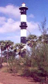
New Machilipatnam Light is shown from a white, round, concrete tower with black bands, 3.8 miles NNE of the mouth of Machilipatnam Creek. The great tsunami of 26 December
2004 swept
away hundreds of people on the beach and reached the base of the lighthouse,
but the tower was ...
Nagayalanka Lighthouse, 15 m hidh, lies 2.3 miles NW of Divi Point and is maintained as a landmark. The station is situated near the mouths of Krishna river. There is a
masonry retaining wall, which serves as jetty. A cement concrete path
way for 500 m from the Lighthouse station ...
False Divi Point is a low headland located at the northern end of the Coromandel Coast, in the state of Andhra Pradesh. It is located at the apex of the Krishna River delta and covered by small mangroves. The area is low, swampy and dominated by mangroves.A bank, which dries in ...
Narasapur Point, low and wooded, lies on the E side of the mouth of the Vasishta Godavari, which is the southernmost branch of the Godavari River. An obelisk, 24.4m high, lies about 1 mile N of the point. During January and February, the current sets W at a maximum rate of 2 ...
Hope Island (16 km long sand spit from the sand carried by the waters of Godavari delta), one of a chain of similar islands which form part of the delta of the Godavari River, is low, swampy, and covered with jungle. The area between Kakinada coast and Hope Island is known as Kakinada ...


 Divi Point is the SE extremity and False Divi Point is the SW extremity of the delta.
")