Nizampatam Bay (Andhra Pradesh-E India)

Nizampatam Bay (Andhra Pradesh-E India)

To precisely geolocate this site. Update if necessary.

Localisation

Nizampatam Bay (Andhra Pradesh-E India)
LatitudeLongitude
DMS------
DM------
DD------

Characteristics

Sea

Description

Nizampatam Bay lies between Kottapatam and False Divi Point, about 41 miles ENE, and recedes about 14 miles to the N. Except for the shoals in the vicinity of Mutapolli Bank, the bay is free from dangers and its shores may be approached with safety to a depth of 9.1m.

A backwater is formed 4 to 6 miles NNE of Kottapatam by the confluence of the Mudigorda Yeru River and the Gundlakamma River. During fine weather, the latter river is available to small boats.

A beacon lies about 0.5 mile within the Mudigorda Yeru River.

From the mouth of the Gundlakamma River, the bay shore curves NE for about 35 miles to the entrance of a creek leading to the town of Nizampatam. Dindi House, a large building with a big high tree close E of it, lies on the N entrance point of the creek.

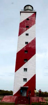
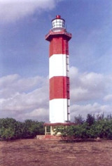
A light is shown from a white tower, 30m high, with red bands.

Between Dindi House and False Divi Point, almost 13 miles to the SE, the coast remains low and sandy.

A beacon lies on the NW entrance point of a boat creek about 5 miles E of Dindi House.

In Nizampatam Bay, weak tidal currents are experienced inshore only at spring tides.

2012/03/28
Update
Jojo
Ebook

Bay of Bengal

  • 110 sites
  • 82 photos
  • publication date: 7 Jul 2023
  • .pdf file size: 53 Mb
Share your comments or photos on "Nizampatam Bay (Andhra Pradesh-E India)"

Sites around Nizampatam Bay (Andhra Pradesh-E India)

Flying distances - Direct line

False Divi Point (E India)

20nm
80°
False Divi Point is a low headland located at the northern end of the Coromandel Coast, in the state of Andhra Pradesh.
It is located at the apex of the Krishna River delta and covered by small mangroves. The area is low, swampy and dominated by mangroves.A bank, which dries in ...
28 Mar 12
Jojo

Mutapolli Bank (E India)

17nm
231°
Mutapolli Bank, with depths of 6.4 to 11m, lies centered about 11 miles E of Kottapatnam. Overfalls usually mark this bank.
Two detached shoals, with depths of 10 to 11m, lie within 5.8 miles SW and three detached shoals, with depths of 9.1 to 11m, lie within 11.3 miles NE of this bank.
28 Mar 12
Jojo

Nagayalanka Lighthouse (Andra Pradesh-E India)

30nm
77°
Nagayalanka Lighthouse, 15 m hidh, lies 2.3 miles NW of Divi Point and is maintained as a landmark.
The station is situated near the mouths of Krishna river. There is a masonry retaining wall, which serves as jetty. A cement concrete path way for 500 m from the Lighthouse station ...
28 Mar 12
Jojo

Divi point (Andhra Pradesh-E India)

42nm
63°
Divi Point is the SE extremity and False Divi Point is the SW extremity of the delta.
Ocean-going local craft use the river for about 6 months of the year.
Krishna Old Light, a white masonry tower, 44m high, lies about 9.5 miles ENE of False Divi Point. Another old lighthouse, ...
28 Mar 12
Jojo

Ramaypatnam Lighthouse (Andra Pradeh-E India)

44nm
214°
Ramaypatnam Light, from which a radiobeacon transmits, is shown from a hexagonal concrete tower lying on the coast 0.8 mile NE of the church at Ramaypatnam, built in 1870, that served as a land mark for the benefit of ships cruising off the Ramaypatnam coast.
The Lighthouse Tower ...
28 Mar 12
Jojo

Machilipatnam port (Andhra Pradesh-E India)

49nm
54°
Machilipatnam (Masulipatam), the only port of the Krishna District, lies about 5 miles within the mouth of the creek of the same name about 11 miles N of Divi Point.
Vessels anchor in the roadstead to handle all cargo to and from native lighters.
Tel: +91 884 2363825 or +91 ...
28 Mar 12
Jojo