North Sands (3°05'N., 101°01'E.) comprises various sand banks and spits lying in a general NW and SE direction between Angsa Bank and One Fathom Bank. The ports within these sand banks are Batu Kineing, Blenhiem Shoal, and Goldfish Bank.
These three areas can be best seen on the chart; a 1.8m wreck lies about 6 miles NW of Blenheim Shoal.
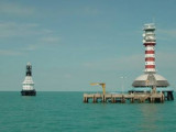
One Fathom Bank (2°53'N., 100°59'E.) is a detached patch, with depths from 3 to 10m, which extends 5 miles in a NW direction reaching 1 mile in width. One Fathom Bank Light is situated 0.6 mile from the SE extremity of the bank. A stranded wreck is situated about 0.7 mile NW ...
Amazon Mara Shoal, with a least depth of 8.4m, lies about 2.2 miles S of One Fathom Bank Light.A dangerous wreck, marked by a lighted buoy, lies in the southeastbound lane of the Traffic Separation Scheme. Another dangerous wreck, with a depth of 16m over it, lies 10 miles WNW of ...
Angsa Bank North Cardinal Light Float is moored off the NW end of Angsa Bank, about 15miles W of Kuala Selangor Light. The bottom is soft and not likely to damage a vessel touching, and the water is invariably smooth. From a position about 12 miles W of Kuala Selangor light, a ...
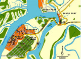
Port Klang is the principal port in Selangor. It also serves as the port for the Klang Valley, Malaysia's most developed region where the capital Kuala Lumpur (that lies 40 miles to the E) is located. The port is situated on the W coast of the Malaysian Peninsula at the N end ...
Pyramid Shoal, which lies on the N side of the SE end of South Sands, has a least depth of 3.4m, hard sand, and is the most dangerous shoal in the area because of its depth and protrusion into the fairway. A lighted buoy is moored about 7 miles SE of Pyramid Shoal. A depth of about ...
Kuala Selangor is conspicuous by the light structure and various small buildings at the foot of a hill. Caution.—The banks off the mouth of the Sungai Selangor are reported to be extending seaward.


 North Sands (3°05'N., 101°01'E.) comprises various sand banks and spits lying in a general NW and SE direction between Angsa Bank and One Fathom Bank.