Kuala Selangor is a town located in Selangor, Malaysia, and is capital of an administrative district of the same name. Selangor is one of the 13 states of Malaysia. It is on the west coast of Peninsular Malaysia and is bordered by Perak to the north, Pahang to the east, Negeri ...
Angsa Bank North Cardinal Light Float is moored off the NW end of Angsa Bank, about 15miles W of Kuala Selangor Light. The bottom is soft and not likely to damage a vessel touching, and the water is invariably smooth. From a position about 12 miles W of Kuala Selangor light, a ...
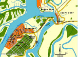
Port Klang is the principal port in Selangor. It also serves as the port for the Klang Valley, Malaysia's most developed region where the capital Kuala Lumpur (that lies 40 miles to the E) is located. The port is situated on the W coast of the Malaysian Peninsula at the N end ...
Pyramid Shoal, which lies on the N side of the SE end of South Sands, has a least depth of 3.4m, hard sand, and is the most dangerous shoal in the area because of its depth and protrusion into the fairway. A lighted buoy is moored about 7 miles SE of Pyramid Shoal. A depth of about ...
Selat Lumut separates the E side of Pulau Lumut from the mainland. It has a least width of about 0.1 mile, with both sides of the S entrance fringed by mud banks. Selat Lumut has not been surveyed in detail, but appears to be navigable by vessels of not more than 3m draft. From ...
Tg Ru is located E side of the approach to Selat Kelang, on Pulau Carey, It is the S point of the South fairway of port Klang . The coast between Tanjong Ru and Tanjong Gabang, about 15 miles SE, is indented about midway along its length by Kuala Langat. This shallow river is not ...


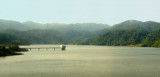


 Kuala Selangor is conspicuous by the light structure and various small buildings at the foot of a hill.
")