Pyramid Shoal, which lies on the N side of the SE end of South Sands, has a least depth of 3.4m, hard sand, and is the most dangerous shoal in the area because of its depth and protrusion into the fairway.
A lighted buoy is moored about 7 miles SE of Pyramid Shoal. A depth of about 10m is charted between this buoy and the shoal. A depth of 13.6m was reported in position 2°23'N, 101°41'E.
Shoal patches of sandwave formation extend into the fairway NE of Pyramid Shoal, the most important being depths of 12.4 and 13.1m lying about 8 miles NW of Pyramid Shoal. These shoals reduce the width of the fairway at this point to about 7 miles and should be avoided by deep-draft vessels. A depth of 17.6m was reported in the fairway 9 miles NNW of Pyramid Shoal and there is a depth of 19.8m 5 miles NNE of the shoal.
Bambeck Shoal, the nearest shoal on the NE side lies on the NE side of the fairway.
Bambek shoal, about 4 NM offshore, lies SW of the mouth of Sungai Sepang Besar. It has a depth of 0,3 m near its center and is composed of hard sand. Its NW and SE sides are steep-to with ...
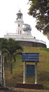
Tanjung Tuan, also called Cape Rachado,
is the site of the oldest - and still functioning - lighthouse in
Malaysia. Cape Rachado Lighthouse, also called Rumah Api Tanjung Tuan,
was built somewhere between 1528 and 1529 by the Portuguese to help
guide ships to the Malacca port. ...
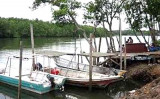
Port Dickson is situated on the W coast of the Malaysian Peninsula facing the Strait of Malacca. The town stretches along the coast in the direction of Tanjung Tuan, located 8 miles SE. Port Dickson is an important oil terminal operated by Shell and Esso, and is a minor port for ...
Admiral
Marina & Leisure Club is within Admiral Cove. Admiral Cove is a concept realised from a desire to create a world class premier
integrated marina resort. Located along the unsploit plains of Port Dickson,
it is today a major international tourist destination.Tel: ...
Pulau Borong, a low densely-wooded rock-fringed islet surrounded by a shallow bank, stands 1.5 miles N of Tanjong Kamuning (that is steep-to with depth of 11 m).