Le Cap d'Ail marque la séparation entre les baies de Beaulieu et de Monaco. Les abords étant malsains, il faut s'en écarter assez largement. Le cap Martin est couvert de pins d'où émerge un sémaphore blanc sur les hauteurs.
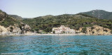
Mento is a small harbor, lies 2 miles NE of Cap Martin. It is protected by two jetties and is used by fishing boats and yachts. The town stands in an amphitheater which is situated on a small promontory at the NE end of a beach. A square tower stands on the extremity of the promontory, ...
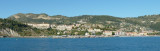
Ventimiglia:Ventimiglia, a town, is situated at the mouth of the Fiume Roja, 2.7 miles E of Capo Mortola. In its W part, the belfry of the cathedral and San Spirito Hospital, a long building, are prominent from seaward. Two prominent bridges stand within 0.4 mile of the river mouth. During ...
The Presqu'ile de Saint Hospice , 40m high, forms a peninsula which extends E from the center of the E side of the Cap Ferrat promontory. It is surmounted by a chapel and a conspicuous tower Pointe Saint Hospice, located 1.2 miles NE of the Cap Ferrat Light, is the E extremity of ...
A small craft harbor, formed by two moles, lies close NE of the cape. It has a depth of 3.5m, but is subject to silting. The port monitors VHF channels 16 and 25.