A small craft harbor, formed by two moles, lies close NE of the cape. It has a depth of 3.5m, but is subject to silting. The port monitors VHF channels 16 and 25.
Le Cap d'Ail marque la séparation entre les baies de Beaulieu et de Monaco. Les abords étant malsains, il faut s'en écarter assez largement. Le cap Martin est couvert de pins d'où émerge un sémaphore blanc sur les hauteurs.
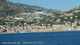
Mento is a small harbor, lies 2 miles NE of Cap Martin. It is protected by two jetties and is used by fishing boats and yachts. The town stands in an amphitheater which is situated on a small promontory at the NE end of a beach. A square tower stands on the extremity of the promontory, ...
A 3 MN de Bordighera le cap Nero marque l'entrée dans la vaste baie de San Remo. Un grand immeuble, au pied duquel se niche le port abri de Capo Pino est remarquable.A partir de ce cap, la côte est bordée de roches et de sèches et il est prudent de s'en écarter au minimum à 500 m.


 A small craft harbor, formed by two moles, lies close NE of the cape. It has a depth of 3.5m, but is subject to silting. The port monitors VHF channels 16 and 25.