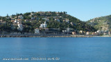
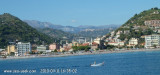
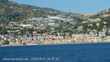
Capo Saint Ampeglio, located 3 miles ESE of the mouth of Fiume Roja, appears low and rises gradually to a summit which is covered with vegetation.
2011/07/19
Update
Atoi
Le cap San Ampeglio, à l'extrémité E de Bordighera, est bas et allongé. Il porte un campanile avec une antenne radio plus au N. Il doit être arrondi à distance pour rejoindre la marina degli Aregai car il n'est pas très franc.
2011/07/19
Update
Atoi
Capo San Ampeglio, alla fine di Bordighera, è bassa e allungata. Indossa un campanile con un'antenna radio al N. Si deve essere arrotondato a distanza per raggiungere la Marina degli Aregai, perché è sopraffatti da rocce.
2010/12/22
Update
Joëlle
2010:09:11 16:39:41
2011-07-19
Update
Atoi
Share your comments or photos on "Capo San Ampeglio"
Le Cap d'Ail marque la séparation entre les baies de Beaulieu et de Monaco. Les abords étant malsains, il faut s'en écarter assez largement. Le cap Martin est couvert de pins d'où émerge un sémaphore blanc sur les hauteurs.
Mento is a small harbor, lies 2 miles NE of Cap Martin. It is protected by two jetties and is used by fishing boats and yachts. The town stands in an amphitheater which is situated on a small promontory at the NE end of a beach. A square tower stands on the extremity of the promontory, ...
A small craft harbor, formed by two moles, lies close NE of the cape. It has a depth of 3.5m, but is subject to silting. The port monitors VHF channels 16 and 25.
The Presqu'ile de Saint Hospice , 40m high, forms a peninsula which extends E from the center of the E side of the Cap Ferrat promontory. It is surmounted by a chapel and a conspicuous tower Pointe Saint Hospice, located 1.2 miles NE of the Cap Ferrat Light, is the E extremity of ...


 Capo Saint Ampeglio, located 3 miles ESE of the mouth of Fiume Roja, appears low and rises gradually to a summit which is covered with vegetation.
 Le cap San Ampeglio, à l'extrémité E de Bordighera, est bas et allongé. Il porte un campanile avec une antenne radio plus au N. Il doit être arrondi à distance pour rejoindre la marina degli Aregai car il n'est pas très franc.
 Capo San Ampeglio, alla fine di Bordighera, è bassa e allungata. Indossa un campanile con un'antenna radio al N. Si deve essere arrotondato a distanza per raggiungere la Marina degli Aregai, perché è sopraffatti da rocce.