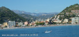

Cap d'Ail - Cap Martin
7.4nm
247°
Le cap Martin est couvert de pins d'où émerge un sémaphore blanc sur les hauteurs.
1 Dec 07
| Latitude | Longitude | |
| DMS | --- | --- |
| DM | --- | --- |
| DD | --- | --- |


 fontaine
 pharmacie


Ebook | Ligure Ligurian Sea
|

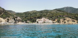
 Porto turistico Cala del Forte
 Porto di Ventimiglia situé à Marina S. Joseph, à été inauguré en juillet 2021
Les travaux ont commencé en avril 2009, devraient être achevés dans 4/5 ans.
La marina sera écologique, elle s'appelle Cala del Forte, nichée dans la baie de Vintimille Scoglietti dominée par l'ancienne ville de Fort de l'Annunziata. Porto di Ventimiglia Situato a Marina S. Giuseppe, è costituito solamente da una scogliera che si protende nel mare.
I lavori cominciato in aprile 2009, dovrebbero essere ultimati in 4/5 anni.
Sarà il porto turistico più ecologico d'Europa. Si chiama Cala del Forte, incastonato nella baia degli Scoglietti a Ventimiglia, dominato dall'alto dall'antico e splendido Forte dell'Annunziata, praticamente affacciato sulla Costa Azzurra..
La superficie totale della concessione è di 140 mila metri quadrati; sono previsti 348 posti barca, da 6,5 a 45 metri di lunghezza; tra le opere a terra 44 appartamenti, 13 mila metri quadri di posteggi, 15 mila di verde pubblico, negozi, bar, cantiere nautico, tre ristoranti e i locali comunali.
P.IVA 01238780082
Via Gianni Cozzi, 1, 18010 Santo Stefano al Mare (Imperia)