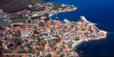
Uvala Zastup, also called Spliska or Splitska is divided into two bays. E arm of the bay is equipped with dock and home to the village of Spliska at the end. Moor head or ass to dock or anchor in the west of the bay by 3 to 12 m deep. Both of the bay are exposed to wind N.
2011/07/5
Update
Jojo
Uvala Zastup, appelée aussi Spliska ou Splitska, est divisée en deux baies. Le bras E de la baie est équipé de quai et abrite le village de Spliska à son extrémité. S'amarrer tête ou cul à quai ou mouiller à l'W de la baie par 3 à 12 m de fond. Les deux partie de la baie sont exposées au vent du N.
Ciovo is an island in the center of the Dalmatian archipelago. This is an area of 28.8 acres (15.3 km length, width of 3.5 km). It culminates at 218 m (Mount Rudin). O. Ciovo forms the SW side of the entrance and inner part of Kastelanski Zaliv. At East side, Ciovo is 2km from ...
Starogradski is a large deep bay, open to the NW, which houses the city and the port of Stari Grad on its SE end. There are several bays, including its N side, where it is possible to anchor. On the other side there is an anchor in front Gradisce.
Plakeni islands, or Cursed Islands, are located at the W and S of Hvar town.
The islands are rocky, covered with bushes and trees. They are usually deserted, except in summer. They offer many choices of moorings sheltered and there is a marina Palmizana.The islands'name ...
Postira just "Postirna" meaning "pasture." It is Postira born the Croatian poet Vladimir Nazor (1876 / 1949). We can dock along the breakwater, dock inside is used by tour boats.
Pakleni Kanal lies between Pakleni Otoci and Otok Hvar. It is a deep and wide channel, with access at both ends, which leads to Luka Hvar. This channel is frequented by small vessels with local knowledge and affords good shelter from the bora, although heavy squalls may be encountered. The ...
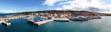
Located around a bay in the shape of a horseshoe, is the administrative center Supetar Brac. It is connected to Split by car ferry frequently. We can dock along the breakwater inside or outside the local boats in the inner part of the port. You can also wet sand on the bay to ...


")
")
 Uvala Zastup, also called Spliska or Splitska is divided into two bays.
 Uvala Zastup, appelée aussi Spliska ou Splitska, est divisée en deux baies.