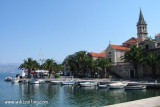
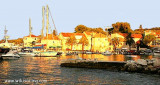
Located around a bay in the shape of a horseshoe, is the administrative center Supetar Brac. It is connected to Split by car ferry frequently.
We can dock along the breakwater inside or outside the local boats in the inner part of the port.
You can also wet sand on the bay to the west of the port, the time for lunch or for shopping. The port is protected from all winds except the NW and N.
2011/07/5
Update
Jojo
Cátering Pipo
2019/06/24
Update
Située autour d'une baie en forme de fer à cheval, Supetar est le centre administratif de Brac. Elle est reliée à Split par un car-ferry fréquent.
On peut s'amarrer le long du brise-lames intérieur ou à l'extérieur des bateaux locaux dans la partie intérieure du port.
On peut aussi mouiller sur du sable dans la baie à l'W du port, le temps d'un déjeuner ou pour faire des courses. Le port est protégé de tous les vents sauf du NW et du N.
Ciovo is an island in the center of the Dalmatian archipelago. This is an area of 28.8 acres (15.3 km length, width of 3.5 km). It culminates at 218 m (Mount Rudin). O. Ciovo forms the SW side of the entrance and inner part of Kastelanski Zaliv. At East side, Ciovo is 2km from ...
Starogradski is a large deep bay, open to the NW, which houses the city and the port of Stari Grad on its SE end. There are several bays, including its N side, where it is possible to anchor. On the other side there is an anchor in front Gradisce.
Plakeni islands, or Cursed Islands, are located at the W and S of Hvar town.
The islands are rocky, covered with bushes and trees. They are usually deserted, except in summer. They offer many choices of moorings sheltered and there is a marina Palmizana.The islands'name ...
Pakleni Kanal lies between Pakleni Otoci and Otok Hvar. It is a deep and wide channel, with access at both ends, which leads to Luka Hvar. This channel is frequented by small vessels with local knowledge and affords good shelter from the bora, although heavy squalls may be encountered. The ...
Uvala Zastup, also called Spliska or Splitska is divided into two bays. E arm of the bay is equipped with dock and home to the village of Spliska at the end. Moor head or ass to dock or anchor in the west of the bay by 3 to 12 m deep. Both of the bay are exposed to wind N.
The port is home to many local boats and you may have to put yourself in these couples. Only small structure can be to dock, the others must anchor in front of the port. The harbor is sheltered from the NE to the west through the S.


 au quai et robinet sur laplace du marché.
 en ville
 en ville
")
 Located around a bay in the shape of a horseshoe, is the administrative center Supetar Brac. It is connected to Split by car ferry frequently.
 Située autour d'une baie en forme de fer à cheval, Supetar est le centre administratif de Brac. Elle est reliée à Split par un car-ferry fréquent.
")
")
")