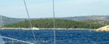
Uvala Vinisce is a great inlet located S of the city of Marina and W Rt Jelinak. SE of Rt Artatur (Tip S of the entrance to the bay) is Hrid Vinisce, a rock 3 m high, which may be difficult to recognize in the background of the rocky mainland coast. Fire on Rt Artatur identifies the entrance to the bay. We anchor to the bottom of the bay or near shore where there is NOT a dock.
2011/08/14
Update
Croatia
Uvala Vinisce est un grand bras de mer situé au S de la ville de Marina et à l'W de Rt Jelinak.
Au SE de Rt Artatur (pointe S de l'entrée de la baie) se trouve Hrid Vinisce, un rocher de 3 m de haut qui peut être difficile à reconnaître sur l'arrière plan de la côte continentale rocheuse. Le feu sur Rt Artatur permet d'identifier l'entrée de la baie.
On mouille au fond de la baie ou près du rivage NE où il y a un appontement.
UvalaVinisce es una gran Ensenada situada de la ciudad de Marina y WRt Jelinak.
SE de RtArtatur (Punta S de la entrada a la Bahía) es HridVinisce , unaroca de 3m de altura,que puede ser difícil reconocer en el fondo de la costa rocosa. Fuego en RtArtatur identifica la entrada a la bahía.
Anclamos en el fondo de la bahía o cerca de la orilla donde no hay un muelle
Ciovo is an island in the center of the Dalmatian archipelago. This is an area of 28.8 acres (15.3 km length, width of 3.5 km). It culminates at 218 m (Mount Rudin). O. Ciovo forms the SW side of the entrance and inner part of Kastelanski Zaliv. At East side, Ciovo is 2km from ...
Island accessible only by sea. It is long about 3 m long by 2 m wide. It is 2 M NW of otok Solta.Its area is 12.07 km ² and its highest point is 178 m.It is separated from the mainland by Drvenicki Kanal. The coast of this beautiful island has remained intact and is made of many ...
Otok Zirje
is the farthest and the largest island in the Sibenik archipelago. It is long of 6,5 NM (NW/SE) and 1,4 NM wide. The main village, Zirje, is located in the middle of the island. A small port, luka Muna, on the coast N of Zirje, home to the ferry that connects the ...
Otok Svetac (Andrija), 305m high, lies 13 miles ESE of Otocic Jabuka and is generally steep-to. The coast of the island is rocky and reddish in color on the NW side. Its SW end is fronted by a few rocks. Hrid Kamik, a dark and jagged above-water rock, lies 0.7 mile W of the SW extremity ...
Wide bay sheltered from all winds, with multiple opportunities for mooring anchor. A marina excellent high-end with all services but expensive. In the middle of the bay lies the island, connected to the mainland by a causeway, on which the village of Rogoznica is built. An old ...


 Uvala Vinisce is a great inlet located S of the city of Marina and W Rt Jelinak.
 Uvala Vinisce est un grand bras de mer situé au S de la ville de Marina et à l'W de Rt Jelinak.
 Entrance Uvala Vinisce