Uvala Rogoznica

Uvala Rogoznica

To precisely geolocate this site. Update if necessary.

Localisation

Characteristics

Coast
Mud
Mooring
Sand
Water prise d'eau près du feu du port
Phone
Market
Grocery
Restaurant
Post
Isolated danger
Beach
Sand
Rock
Wreck Rt Konj

Description

Uvala Rogoznica
Uvala Rogoznica
2011-04-03
Update
Jojo
Uvala Rogoznica
Uvala Rogoznica
2011-04-03
Update
Jojo
Uvala Rogoznica
Uvala Rogoznica
2011-04-03
Update
Jojo
Ebook

Šibensko-kninska županija (Šibenik-Knin County)

  • 99 sites
  • 182 photos
  • publication date: 7 Jul 2023
  • .pdf file size: 59 Mb
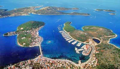
Wide bay sheltered from all winds, with multiple opportunities for mooring anchor. A marina excellent high-end with all services but expensive.
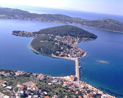
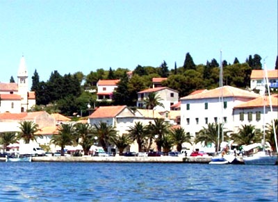
In the middle of the bay lies the island, connected to the mainland by a causeway, on which the village of Rogoznica is built. An old fishing village, well preserved with good restaurants, a few slips.
Good protection from all directions.
Entry and anchorages can sail in different locations.
Approach: Approaching the S, it is possible, weather permitting, to pass between the island Smokvica Vela Smokvica Vela and Rt Movares, staying at the E fire on the island of Hrid Kalebinjak. From here, to proceed from the N passing at 0.1 M Konjit Rt. Attention to the wreckage of Konjit Rt. The currents around Rt Konjit can be strong. Once past Konjit turn into the bay.
One can also go to the W Smokvica Otok Vela. Beware of unmarked shoal, Plicina Smokvica (5 m), 0.4 M NW Smokvica Otok Vela. A shoal on which the sea breeze extends to about 0.2 M to W Smokvica Otok Mala, indicated by a tag without fire. There is a mooring buoy in the channel to the NE of the island Smokvica Mala.

Approaching from the N, beware Greben Grbavac rock marked by a beacon light, about 4 million to the NW of the entrance, and Veli Plicina Brak, shoal marked by a buoy without light at 1 M N Hrid Mulo.

We Can moor at the wharf on the W coast of the island by 2 m.

We can anchor by 10/12 m, E village, near the floor.
You can anchor in Uvala Stupin, NE of the bay, 8 / 10 m.
2011/08/8
Update
MamJo
Uvala Rogoznica
Uvala Rogoznica
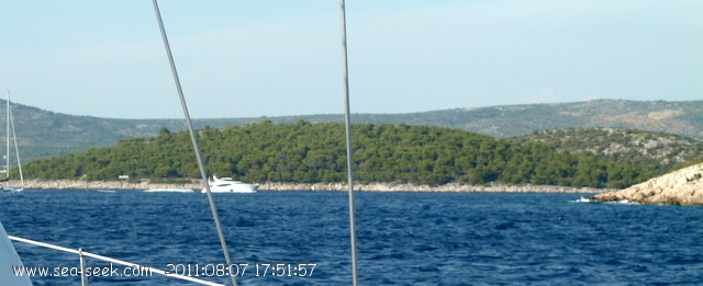
L'entrée de U. Rognoznica ne se voit pas du large en arrivant par le S. Au premier plan on aperçoit Rt Konj.
2011:08:07 17:51:57
2011-08-08
Update
JB
Vaste baie bien abritée de tous les vents, avec de multiples possibilités de mouillage sur ancre. Une marina excellente très haut de gamme avec tous services mais chère.

Au milieu de la baie se trouve l'île, reliée au continent par une chaussée, sur laquelle le village de Rogoznica est bâti. Un vieux village de pêcheurs bien conservé avec de bons restaurants, quelques places à quai.

Bonne protection de toutes les directions.

Entrée et mouillages à la voile possible dans différents endroits.

Approche: En approchant par le S, il est possible, par beau temps, de passer entre Rt Movar et l'île Smokvica Vela, en restant à l'E du feu sur l'îlot d'Hrid Kalebinjak. De là, faire route au N en passant à 0,1 M de Rt Konj. Attention à l'épave de Rt Konj. Les courants autour de Rt Konj peuvent être forts. Une fois passé Konj virer dans la baie.
On peut aussi passer à l'W d'Otok Smokvica Vela. Attention au haut-fond non balisé, Plicina Smokvica (5 m) , à 0,4 M au NW d'Otok Smokvica Vela. Un haut-fond sur lequel la mer se brise, s'étend à environ 0,2 M à l'W d'Otok Smokvica Mala, signalé par une balise sans feu. Il y a une bouée de corps-mort dans le chenal, au NE de l'île Smokvica Mala.

En approchant par le N, attention à Greben Grbavac, rocher signalé par une balise lumineuse, à environ 4 M au NW de l'entrée, et à Plicina Veli Brak, haut-fond signalé par une bouée sans feu à 1 M au N de Hrid Mulo.

On peut s'amarrer au quai sur la côte W de l'île par 2 m.

On peut mouiller par 10/12 m, à l'E du village, près de la chaussée.

On peut mouiller dans Uvala Stupin, au NE de la baie, par 8/10 m.

2011/06/20
Update
Jojo
Share your comments or photos on "Uvala Rogoznica"

Sites around Uvala Rogoznica

Flying distances - Direct line

Otok Ciovo

13nm
98°
Ciovo is an island in the center of the Dalmatian archipelago. This is an area of 28.8 acres (15.3 km length, width of 3.5 km). It culminates at 218 m (Mount Rudin).
O. Ciovo forms the SW side of the entrance and inner part of Kastelanski Zaliv.
At East side, Ciovo is 2km from ...
7 Aug 11
cdg2

Otok Zirje (Sibenik)

15nm
298°
Otok Zirje is the farthest and the largest island in the Sibenik archipelago.
It is long of 6,5 NM (NW/SE) and 1,4 NM wide.
The main village, Zirje, is located in the middle of the island. A small port, luka Muna, on the coast N of Zirje, home to the ferry that connects the ...
16 Aug 11
Croatia

Otok Svetac (Andrija)

31nm
197°
Otok Svetac (Andrija), 305m high, lies 13 miles ESE of Otocic Jabuka and is generally steep-to. The coast of the island is rocky and reddish in color on the NW side. Its SW end is fronted by a few rocks. Hrid Kamik, a dark and jagged above-water rock, lies 0.7 mile W of the SW extremity ...
25 May 11
Jojo

Zlarinski Kanal

10nm
322°
Zlarinski Kanal leads along the SW side of Otok Zlarin and is entered midway between Rt Rat and Otocic Komorica, a small islet marked by a light, 1.5 miles SW.
This channel is sometimes used as an alternate route to Sibenik by vessels entering Sibenska Vrata, the middle passage, ...
21 Jun 11
Jojo

Otok Drvenik Veli

9.4nm
122°
Island accessible only by sea. It is long about 3 m long by 2 m wide. It is 2 M NW of otok Solta.Its area is 12.07 km ² and its highest point is 178 m.It is separated from the mainland by Drvenicki Kanal.
The coast of this beautiful island has remained intact and is made of many ...
18 Aug 11
Croatia

Otok Murter

22nm
315°
The island of Murter is the largest island of the Sibenik archipelago. It is close to the coast on which it is connected by a bridge, low air draft at Tijesno (Tisno) on the continent. During the summer the bridge opens to allow passage of boats.
The NW part of the island is fertile ...
3 Apr 11
Jojo