Uvala Skrivena Luka Lastovo

Uvala Skrivena Luka Lastovo

To precisely geolocate this site. Update if necessary.

Localisation

Characteristics

Grass
Mud Bonne tenue
Mooring
Restaurant rive W
Beach
Sand

Description

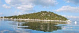
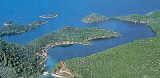
Skrivena Luka means Hidden bay. It is a village and small bay on the southern coast of the island of Lastovo. Skrivena Luka is also known as "Portorus" . This bay is so secluded that it is not possible to see it
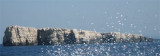
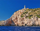
 from the open seas.

The cape Struga, that forms the eastern part of Skrivena Luka has a lighthouse that is built here in 1839, and is one of the oldest lighthouses on the Adriatic Sea.

Skrivena Luka is a good place to anchor, as it is well secluded and sheltered form open sea and strong winds

The entrance is narrow with a depth of 6 m in the channel.
Good protection inside.
We anchor by 10 to 12 m. There are few docks around the bay but there is little of substance.

2011/05/10
Update
Jojo
Uvala Skrivena Luka Lastovo
2011-05-10
Update
Jojo
Skrivena Luka signifie baie cachée. C'est un village et une petite baie sur la côte sud de l'île de Lastovo. Skrivena Luka est également connue comme "Portorus". Cette baie est si isolée qu'il n'est pas possible de la voir du large.
Le cap Struga, qui forme la partie orientale de Skrivena Luka a un phare qui fut construit en 1839, et est l'un des plus anciens phares sur la mer Adriatique.

Skrivena Luka est un bon endroit de mouillage, car il est bien isolé et protégé des vents et de la houle.

L'entrée est étroite avec une profondeur minimale de 6 m dans le chenal.

Bonne protection à l'intérieur.

On mouille par 10 à 12 m. Il y a quelques quais autour de la baie mais il y a peu de fond.

2011/05/10
Update
Jojo
Uvala Skrivena Luka Lastovo
2011-05-10
Update
Jojo
La konoba (petit restaurant) Porto Rosso, dans la baie de Skrivena Luka (côté ouest). Une escale du bout du monde avec une ambiance familiale, de bons plats et un très bon accueil!
2012/01/31
Update
Gérard
Vue sur la baie de Skrivena Luka depuis le Hum, le plus haut sommet de Lastovo (417m).
2012/01/31
Update
Gérard
Uvala Skrivena Luka Lastovo
2011:10:17 10:24:16
2012-02-01
Update
Gérard
Uvala Skrivena Luka Lastovo
2009:10:11 17:25:43
2012-02-01
Update
Gérard
Ebook

Dubrovačko-neretvanska županija (Dubrovnik–Neretva

  • 140 sites
  • 228 photos
  • publication date: 6 Aug 2024
  • .pdf file size: 79 Mb
Ebook

Dalmacija (Dalmatie)

  • 568 sites
  • 963 photos
  • publication date: 5 Aug 2024
  • .pdf file size: 350 Mb
Share your comments or photos on "Uvala Skrivena Luka Lastovo"

Sites around Uvala Skrivena Luka Lastovo

Flying distances - Direct line

Rt Struga Lastovo

0.6nm
194°
In the middle of the southern side of the island of Lastovo, at the entrance to the bay of Skrivena Luka lies the Cape of Struga where the lighthouse of the same name was built in 1839.  The lighthouse lies at the height of 70 m.
10 May 11
Jojo

Luka Velji Lago Lastovo

3.8nm
288°
Luka Velji Lago is a deep cove lined by O. Lastovo to E & O. Prezba the N and W.
The entrance is on the W coast of Lastovo.
The different parts of the cove are sheltered from all winds.
From the S, through the middle between O. Bratin and Lastovo, continue heading N until ...
10 May 11
Jojo

Otok Prezba

3.8nm
299°
Prežba is a small uninhabited island in the Croatian part of the Adriatic Sea, located northwest of the island of Lastovo in southern Dalmatia.
It is connected to Lastovo by a bridge at the village of Pasadur on Lastovo.
Prežba's area is 2.81 km², but its coastline ...
11 May 11
Jojo

Otok Kopiste Lastovo

8nm
278°
L'île Kopiste appartient au groupe d'îles du parc naturel de Lastovo. Elle est située à l'W de Lastovo après O. Przba et O. Mrcara dont elle est séparée par le canal de Zaplja.
Elle est entourée de trois îlots: O. Bijelac, O. Pod Kopiste et O Crnac.
11 May 11
Jojo

Uvala Zaklopatica Lastovo

2.3nm
345°
This bay is located on the N side of Lastovo. It is sheltered behind the island of Poklopac and is protected from all winds except NE.
It enters through E of the island in the deep channel of 7 m.
You can anchor the middle of the bay by 13 to 15 m. Towards the end of the bay ...
11 May 11
Jojo

Luka Mali Lago Lastovo

3.4nm
312°
Luka Mali Lago is situated on the coast N of O. Lastovo. The bay is bordered by the Lastovo S, E and N, and O. Prezba to W.
Shallower than Luka Velji Lago, it communicates with it by a channel for boats with low TE and a low road bridge.
Can moor at the marina Solitudo near ...
11 May 11
Jojo