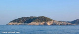

Otok Kopiste Lastovo
4.2nm
269°
Elle est entourée de trois îlots: O. Bijelac, O. Pod Kopiste et O Crnac.
11 May 11
Jojo
| Latitude | Longitude | |
| DMS | --- | --- |
| DM | --- | --- |
| DD | --- | --- |


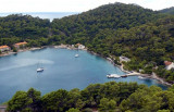
 Luka Velji Lago is a deep cove lined by O. Lastovo to E & O. Prezba the N and W.
 Luka Velji Lago est une anse profonde bordée par O. Lastovo à l'E et O. Prezba au N et à l'W.
L'entrée se trouve sur la côte W de Lastovo.
Les différentes parties de l'anse sont abritées de tous les vents.
En venant du S, passer au milieu entre O. Bratin et Lastovo, continuer cap au N jusqu'à ce que la bouée sans feu marquant le haut-fond au large de Rt Curf soit par le travers. Viere alors en passant au N de la bouée.
En venant par le N, attention à la zone de hauts-fonds couverte par 5 m, s'étendant jusqu'à 0,3 m à l'W de Otocic pod Mrcaru (feu).
Au SW au S se trouvent deux autres hauts-fonds plus importants.
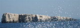
A environ 1,6 NM à l'WSW d'O. Mrcara, il y a un îlot sans feu entouré de hauts-fonds.
Une fois passé O. Mrcara on peut passer au N ou au S d'O. Bratin et entrer dans le port en passant au N de la bouée sans feu sur la rive S de l'entrée au niveau de Rt Cuf.
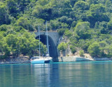
Plusieurs mouillages sont possibles dans cette anse.
Ebook | Dubrovačko-neretvanska županija (Dubrovnik–Neretva
|
Ebook | Dalmacija (Dalmatie)
|