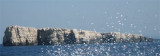
In the middle of the southern side of the island
of Lastovo, at the entrance to the bay of Skrivena Luka lies the Cape of
Struga where the lighthouse of the same name was built in 1839. The lighthouse lies at the height of 70 m.
2011/05/10
Update
Jojo
Le cap Struga se situe au milieu du côté sud de
l'île de Lastovo a l'entrée de la baie Skrivena luka. Le phare Struga y
fut construit en 1839. Il est haut de 70 m.
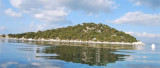
Skrivena Luka means Hidden bay. It is a village and small bay on the
southern coast of the island of Lastovo. Skrivena Luka is also known as
"Portorus" . This bay is so secluded that it is not possible to see it
from the open seas. The cape Struga, that forms the eastern part ...
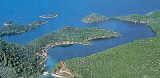
Luka Velji Lago is a deep cove lined by O. Lastovo to E & O. Prezba the N and W. The entrance is on the W coast of Lastovo. The different parts of the cove are sheltered from all winds. From the S, through the middle between O. Bratin and Lastovo, continue heading N until ...
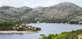
Prežba is a small uninhabited island in the Croatian part of the Adriatic Sea, located northwest of the island of Lastovo in southern Dalmatia. It is connected to Lastovo by a bridge at the village of Pasadur
on Lastovo. Prežba's area is 2.81 km², but its coastline ...
L'île Kopiste appartient au groupe d'îles du parc naturel de Lastovo. Elle est située à l'W de Lastovo après O. Przba et O. Mrcara dont elle est séparée par le canal de Zaplja. Elle est entourée de trois îlots: O. Bijelac, O. Pod Kopiste et O Crnac.
This bay is located on the N side of Lastovo. It is sheltered behind the island of Poklopac and is protected from all winds except NE. It enters through E of the island in the deep channel of 7 m. You can anchor the middle of the bay by 13 to 15 m. Towards the end of the bay ...
Luka Mali Lago is situated on the coast N of O. Lastovo. The bay is bordered by the Lastovo S, E and N, and O. Prezba to W. Shallower than Luka Velji Lago, it communicates with it by a channel for boats with low TE and a low road bridge. Can moor at the marina Solitudo near ...


 In the middle of the southern side of the island
of Lastovo, at the entrance to the bay of Skrivena Luka lies the Cape of
Struga where the lighthouse of the same name was built in 1839. The lighthouse lies at the height of 70 m.
In the middle of the southern side of the island
of Lastovo, at the entrance to the bay of Skrivena Luka lies the Cape of
Struga where the lighthouse of the same name was built in 1839. The lighthouse lies at the height of 70 m. Le cap Struga se situe au milieu du côté sud de
l'île de Lastovo a l'entrée de la baie Skrivena luka. Le phare Struga y
fut construit en 1839. Il est haut de 70 m.
Le cap Struga se situe au milieu du côté sud de
l'île de Lastovo a l'entrée de la baie Skrivena luka. Le phare Struga y
fut construit en 1839. Il est haut de 70 m.