This bay is located on the N side of Lastovo. It is sheltered behind the island of Poklopac and is protected from all winds except NE. It enters through E of the island in the deep channel of 7 m. You can anchor the middle of the bay by 13 to 15 m. Towards the end of the bay funds decreased up to 7 m. It can dock at the facility that borders the bay.
2011/05/11
Update
Jojo
Cette baie est située sur la côte N de Lastovo. Elle est abritée derrière l'île de Poklopac et est protégée de tous les vents à l'exception du NE.
On entre en passant à l'E de l'île, dans le chenal profond de 7 m.
On peut mouiller au milieu de la baie par 13 à 15 m. Vers le fond de la baie les fonds diminuent jusqu'à 7 m.
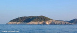
Prežba is a small uninhabited island in the Croatian part of the Adriatic Sea, located northwest of the island of Lastovo in southern Dalmatia. It is connected to Lastovo by a bridge at the village of Pasadur
on Lastovo. Prežba's area is 2.81 km², but its coastline ...
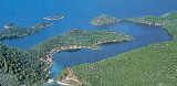
Luka Velji Lago is a deep cove lined by O. Lastovo to E & O. Prezba the N and W. The entrance is on the W coast of Lastovo. The different parts of the cove are sheltered from all winds. From the S, through the middle between O. Bratin and Lastovo, continue heading N until ...
L'île Kopiste appartient au groupe d'îles du parc naturel de Lastovo. Elle est située à l'W de Lastovo après O. Przba et O. Mrcara dont elle est séparée par le canal de Zaplja. Elle est entourée de trois îlots: O. Bijelac, O. Pod Kopiste et O Crnac.
Luka Mali Lago is situated on the coast N of O. Lastovo. The bay is bordered by the Lastovo S, E and N, and O. Prezba to W. Shallower than Luka Velji Lago, it communicates with it by a channel for boats with low TE and a low road bridge. Can moor at the marina Solitudo near ...
Zaljev Vela Luka is a large bay on the E O. Korcula. Many coves occupy the bay. At the bottom of it is the port of Vela Luka, an active and well sheltered. Easily identifiable by day or night, you can enter this great bay in all weather. Dangers in the general approach are the ...
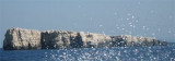
Mrcara is one of 46 islands and islets that consist the Archipelago of the Island Lastovo.
It is part of Lastovo Nature Park, it is the "bird island" which has an area of 147 ha of which 90% is covered with forest. Mrcara is about 2,5 miles away from Ubli, the Port ...


 quai
quai

 This bay is located on the N side of Lastovo. It is sheltered behind the island of Poklopac and is protected from all winds except NE.
 Cette baie est située sur la côte N de Lastovo. Elle est abritée derrière l'île de Poklopac et est protégée de tous les vents à l'exception du NE.