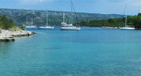
Uvala Manastir or Mostir is located at E Lovisce Luka, on the N side of O. Scedro. At the bottom of the bay is the Dominican monastery (founded in the fifteenth century and abandoned in the seventeenth century) who gave his name to the creek. No dangers in the approach. We anchor by 8 m. Good protection from NW to NE through S.
2011/05/26
Update
Jojo
Uvala Manastir ou Mostir est située à l'E de Luka Lovisce, sur le côté N de O. Scedro. Au fond de la baie se trouve le monastère dominicain (fondé au XVème siècle et abandonné au XVIIème siècle) qui a donné son nom à la crique.
Starogradski is a large deep bay, open to the NW, which houses the city and the port of Stari Grad on its SE end. There are several bays, including its N side, where it is possible to anchor. On the other side there is an anchor in front Gradisce.
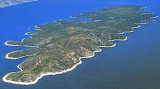
Otok Scedro lies 3 miles E of Hridi Lukavci. It is 2,7 km off the S coast of island of Hvar.The inhabited island is elevated at each end and slopes towards the sea in the middle. Its coastline includes many coves where you can get wet. The two most popular are Uvala Uvala Lovisce ...
Zaljev Vela Luka is a large bay on the E O. Korcula. Many coves occupy the bay. At the bottom of it is the port of Vela Luka, an active and well sheltered. Easily identifiable by day or night, you can enter this great bay in all weather. Dangers in the general approach are the ...
Plakeni islands, or Cursed Islands, are located at the W and S of Hvar town.
The islands are rocky, covered with bushes and trees. They are usually deserted, except in summer. They offer many choices of moorings sheltered and there is a marina Palmizana.The islands'name ...
Pakleni Kanal lies between Pakleni Otoci and Otok Hvar. It is a deep and wide channel, with access at both ends, which leads to Luka Hvar. This channel is frequented by small vessels with local knowledge and affords good shelter from the bora, although heavy squalls may be encountered. The ...
This large bay is composed of 3 creeks. It is located on the N side of O. Lovisce and carries a light at the entrance on Rt G Kurilo. We anchored in one of the coves by 8 to 10 m. Good protection except from N.


 Uvala Manastir or Mostir is located at E Lovisce Luka, on the N side of O. Scedro.
 Uvala Manastir ou Mostir est située à l'E de Luka Lovisce, sur le côté N de O. Scedro.