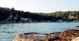
This bay consists of several branches sheltered from all winds. The mooring is paid, the trash is collected in the morning it offers fresh bread, milk and even newspapers (Croatian of course).
2011/07/5
Update
Jojo
Restaurant serves only fish unless anything else is ordered in advance. There is no menu and the bill was somewhat of a surprise.
2012/07/15
Update
Cette grande baie est constituée de plusieurs branches abritées de tous les vents. Le mouillage est payant, les poubelles sont collectées, le matin on vous propose du pain frais, du lait et même des journaux (Croates bien sûr).
2011/07/5
Update
Jojo
2012:07:11 14:36:50
2012-07-15
Update
Share your comments or photos on "Uvala Lucice (Brac)"
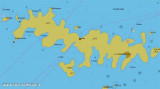
Ciovo is an island in the center of the Dalmatian archipelago. This is an area of 28.8 acres (15.3 km length, width of 3.5 km). It culminates at 218 m (Mount Rudin). O. Ciovo forms the SW side of the entrance and inner part of Kastelanski Zaliv. At East side, Ciovo is 2km from ...
Plakeni islands, or Cursed Islands, are located at the W and S of Hvar town.
The islands are rocky, covered with bushes and trees. They are usually deserted, except in summer. They offer many choices of moorings sheltered and there is a marina Palmizana.The islands'name ...
Starogradski is a large deep bay, open to the NW, which houses the city and the port of Stari Grad on its SE end. There are several bays, including its N side, where it is possible to anchor. On the other side there is an anchor in front Gradisce.
Pakleni Kanal lies between Pakleni Otoci and Otok Hvar. It is a deep and wide channel, with access at both ends, which leads to Luka Hvar. This channel is frequented by small vessels with local knowledge and affords good shelter from the bora, although heavy squalls may be encountered. The ...
The island Sveti Klement is the largest of the "Pakleni Otoci".
Its area is 5.27 square kilometers and it has 29.891 km of rocky coasts. A portion of the island, whose highest peak, Glavica, is 94 m high, is covered with scrub and pine woods. The island is surrounded by ...


") l'anse du centre de la baie
l'anse du centre de la baie")
") L'anse située à babord en entrant dans la baie
L'anse située à babord en entrant dans la baie")
") L'anse à tribord
L'anse à tribord This bay consists of several branches sheltered from all winds.
 Cette grande baie est constituée de plusieurs branches abritées de tous les vents.
")