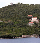
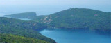
Gornji Molunat is the large bay that is located S of Peninsula Molunat, 18 NM from Dubrovnik. The entrance to this bay is protected by an island (O. Veliki Skolj) and an islet (Supetric). The best entrance is between Supetric and the mainland, passing closest to the mainland than the island, by 10 m deep. We anchor by 8 / 9 m. Good protection except SE winds.
2011/04/11
Update
Jojo
Gornji Molunat est la large baie qui se trouve au S de la péninsule Molunat, à 18 MN de Dubrovnik. L'entrée de cette baie est protégée par une île (O. Veliki Skolj) et un îlot (Supetric).
La meilleure entrée se fait entre Supetric et le continent, en passant plus près du continent que de l'îlot, par 10 m de fond.
The middle bay of Boka Kotorska, is connected to Topaljski Zaliv by Kumborski Strait, a deep passage. This bay is steep and rocky on its S side, but the NE and NW shores, which are backed by mountains, are low and cultivated. Uvala Kukuljina and UvalaKrtole, separated from each ...
Rt Jubuka (42°27'N., 18°25'E.), located 7 miles NW of Ostri Rt, is the NW extremity of a hammerhead shaped projection which extends 1 mile offshore and forms two small bights. Ostrvo Molunat is the largest of two small islets which lie close off the SE extremity of this projection. ...
Donji Molunat lies N of the peninsula Molunat, it cuts deep into the earth and is narrower than its neighbor of S. But also much deeper (16 to 24 m) and should be worn throughout earth.
It is the largest and most populated island of the group Elafiten. It rises to 234 m at its N and a prominent hill rises 224 m NW of the SE end. Ruda is a small island that is 0.5 M SE of the NE extremity of the island and Misnjaka, 13 m high, lies close off the NW extremity. ...
Herceg Novi is located N of the entrance of Bay of Kotor on the coast N Hercegnovi Zaljev. It is a popular seaside resort with bars near the port that make port noise. The port is the subject of a constant traffic of tour boats and ferries, which operate late at night and create ...
Zupski Zaliv is entered between Rt Sustjepan and Rt Pelegrin, 2.5 miles NW. The E and SE shores of this bay are backed by mountains, but a valley through which a river flows lies within the N shore. Malastica, 628m high, stands 1 mile N of the bay. This hill has a somewhat sharp ...


 aux campings
 à Molunat
 à Molunat
 à Molunat
 Gornji Molunat is the large bay that is located S of Peninsula Molunat, 18 NM from Dubrovnik. The entrance to this bay is protected by an island (O. Veliki Skolj) and an islet (Supetric).
 Gornji Molunat est la large baie qui se trouve au S de la péninsule Molunat, à 18 MN de Dubrovnik. L'entrée de cette baie est protégée par une île (O. Veliki Skolj) et un îlot (Supetric).