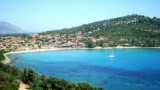
The large bay of Cea is known and recognizable by the presence to a few meters from the shore, of two red rocks shaped chimneys, called "Is Scoglius Arrubius" (Arrubius means red), particularly popular with divers.
You can anchor near the small cove S of the bay.
2012/10/12
Update
Joëlle
La grande baie de Cea est connue et reconnaissable par la présence, à quelques mètres de la rive, de deux rochers rouges en forme de cheminées, appelés "Is Scoglius Arrubius" ( Arrubius signifie rouge), particulièrement apprécié par les plongeurs.
On peut mouiller vers la petite crique située au S de la grande baie.
2012/10/11
Update
Joëlle
La granda baia di Cea è conosciuta per la presenza di spettacolari faraglioni di granito, chiamati "Is Scoglius Arrubius" ( Arrubius che significa rosso), ergono nell’insenatura e sono particolarmente popolare tra i subacquei.
Gulf di Tortoli is entered between Isola dell’Ogliastra and Capo Bellavista, marked by a light, 2.5 miles S. Winds from the NW and NE quadrants come up suddenly and blow with extreme violence in this vicinity. They may last for 4 or 5 days and are preceded by whitish clouds ...
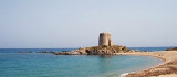
The Bari tower, remarkable, is an ancient medieval tower on the east coast of Sardinia, in the province of Ogliastra, 4.5 km from the city of Bari Sardo.
Bari Tower stands on a rocky promontory, advancing towards the sea, and is bordered by a sandy beach, called Bari beach.The ...
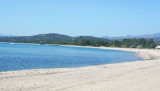
San Gemiliano cove opens at the most northern end of a long beach, sheltered by the promontory of Bellavista cape and a small tip that comes off, at the top of which stands the ruined tower `San Gemiliano. The western side of the tip is bordered by emerging rocks and shoals and ...
S Bellavista cape, between Sud S. Gemiliano point and N Frailis point, leads a small bay with a beautifull sandy beac. On the W point of the entry we see S. Gemiliano tower, 42 m high. N promontory is the Arbatax harbour.Beware to numerous rocks present in the bay.We anchor in ...
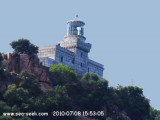
Bellavista cape is a rugged promontory, 150 m high and connected to the shore by a lower land, so that, seen from N or S, it seems an island. It has a lighthouse at its peak, crenellated tower 19 m high, backed by a one floor house, painted in black and white horizontal stripes. ...
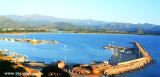
The port of Arbatax lies in the S part of Golfo di Tortoli and on the N side of the promontory of Capo Bellavista. It is the only refuge on the E coast of Sardegna to the S of Olbia.
Tel. 0782.667405 Fax 0782.664359 Berths: 400 Berths Transit: 150 (<80 m)


")
")
")
")
 The large bay of Cea is known and recognizable by the presence to a few meters from the shore, of two red rocks shaped chimneys, called "Is Scoglius Arrubius" (Arrubius means red), particularly popular with divers.
 La grande baie de Cea est connue et reconnaissable par la présence, à quelques mètres de la rive, de deux rochers rouges en forme de cheminées, appelés "Is Scoglius Arrubius" ( Arrubius signifie rouge), particulièrement apprécié par les plongeurs.
 La granda baia di Cea è conosciuta per la presenza di spettacolari faraglioni di granito, chiamati "Is Scoglius Arrubius" ( Arrubius che significa rosso), ergono nell’insenatura e sono particolarmente popolare tra i subacquei.
")