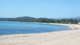
S Bellavista cape, between Sud S. Gemiliano point and N Frailis point, leads a small bay with a beautifull sandy beac. On the W point of the entry we see S. Gemiliano tower, 42 m high. N promontory is the Arbatax harbour.
Beware to numerous rocks present in the bay.
We anchor in 4 to 8 m, at about 0,3 NM SE tower.
Sheltered of NW winds.
2012/10/11
Update
Joëlle
Au S du cap Bellavista, entre la pointe S. Gemiliano au S et la pointe Frailis au N, s'ouvre une petite baie bordée d'une belle plage de sable. Sur la pointe W de l'entrée on voit la tour de S. Gemiliano, haute de 42 m. Sur la face N du promontoire se trouve le port d'Arbatax.
Attention aux nombreux rochers présents dans cette rade.
On mouille par 4 à 8 m, à environ 0,3 MN au SE de la tour.
Abritée des vents du NW.
2012/10/11
Update
Joëlle
S capo Bellavista, fra la punta S. Gemiliano a S e la punta Frailis a N, si apre una picola baia con una bella spiaggia di sabbia.
Sulla punta W dell'entrata si vede la torre di S. Gemiliano, alta di 42 m. Sulla facia N del promontorio si trova il porto di Arbatax.
La baia è riparata dai venti NW e circondata da scogli piatti su entrambi i lati. Sono molto pericolose le numerose secche e gli scogli presenti in rada, alle quali si deve prestare particolare attenzione.
Si ancora in 4 a 8 m, a circa 0,3 MN SE dalla torre.
Gulf di Tortoli is entered between Isola dell’Ogliastra and Capo Bellavista, marked by a light, 2.5 miles S. Winds from the NW and NE quadrants come up suddenly and blow with extreme violence in this vicinity. They may last for 4 or 5 days and are preceded by whitish clouds ...
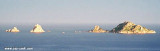
Bellavista cape is a rugged promontory, 150 m high and connected to the shore by a lower land, so that, seen from N or S, it seems an island. It has a lighthouse at its peak, crenellated tower 19 m high, backed by a one floor house, painted in black and white horizontal stripes. ...
San Gemiliano cove opens at the most northern end of a long beach, sheltered by the promontory of Bellavista cape and a small tip that comes off, at the top of which stands the ruined tower `San Gemiliano. The western side of the tip is bordered by emerging rocks and shoals and ...
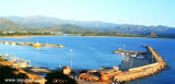
The port of Arbatax lies in the S part of Golfo di Tortoli and on the N side of the promontory of Capo Bellavista. It is the only refuge on the E coast of Sardegna to the S of Olbia.
Tel. 0782.667405 Fax 0782.664359 Berths: 400 Berths Transit: 150 (<80 m)
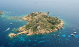
Isola dell’Ogliastra, 47m high, lies 3 miles S of Punta Pedra Longa and is in front of Lotzorai beach. It is reddish, rocky, and covered with scanty vegetation. Several rocks extend up to 0.2 mile seaward off its NE side.There are many coves that offer tamporal anchorage . The ...
Anchorage can be taken, in a depth of 15m, sand and weed, about 0.2 mile SSW of Isola dell’Ogliastra or in a depth of 8m, about 200m W of the islet, but these berths are dangerous in SE winds.


 S Bellavista cape, between Sud S. Gemiliano point and N Frailis point, leads a small bay with a beautifull sandy beac.
 Au S du cap Bellavista, entre la pointe S. Gemiliano au S et la pointe Frailis au N, s'ouvre une petite baie bordée d'une belle plage de sable.
 S capo Bellavista, fra la punta S. Gemiliano a S e la punta Frailis a N, si apre una picola baia con una bella spiaggia di sabbia.
")
") La tour S. Emiliano
La tour S. Emiliano") Tour S. Emiliano
Tour S. Emiliano")
")