The Keys ( Florida)

The Keys ( Florida)

To precisely geolocate this site. Update if necessary.

Localisation

The Keys ( Florida)
LatitudeLongitude
DMS------
DM------
DD------

Characteristics

Coast

Description

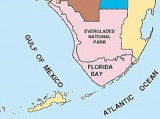
The Florida Keys are a chain-like cluster of about 1700 islands in the southeast United States. They begin at the southeastern tip of the Florida peninsula, about 15 miles (24 km) south of Miami, and extend in a gentle arc south-southwest and then westward to Key West, the westernmost of the inhabited islands, and on to the uninhabited Dry Tortugas.
The islands lie along the Florida Straits, dividing the Atlantic Ocean to the east from the Gulf of Mexico to the west, and defining one edge of Florida Bay.
At the nearest point, the southern tip of Key West is just 94 miles (151 km) from Cuba.

The Keys were long accessible only by water. This changed with the completion of Henry Flagler's Overseas Railway in the early 1910s. Flagler, a major developer of Florida's Atlantic coast, extended his Florida East Coast Railway down to Key West with an ambitious series of over-sea railroad trestles.

The Florida Keys and Florida Reefs are of sand, shell, and coral formation. The reefs have frequent shoal patches. Together, they form the N boundary of the Straits of Florida. Toward the W end are several openings between the keys offering passage from the straits into the Gulf.

2012/04/7
Update
India
The Keys ( Florida)
The Keys ( Florida)
2015-07-07
Update
Island safari tours.
Les Keys de Floride sont un archipel d'environ 1700 îles, situé à l'extrémité sud des États-Unis sur le détroit de Floride qui sépare l'océan Atlantique du Golfe du Mexique.
Il forme la baie de Floride et s'étend du sud-est de la péninsule de Floride, près de Miami, prend une direction sud puis s'oriente vers l'ouest à Key West ; il se termine sur les îles inhabitées de Dry Tortugas.
Key West se trouve à 145 km seulement de Cuba.

Key Biscayne est en fait rattachée au continent et certains ne la considèrent pas comme une des Keys. Le siège du comté de Monroe se trouve à Key West.

Les Keys furent longtemps seulement accessibles en bateau. Cela fut changé grâce à Henry Flager qui mis en place une voie ferrée au-dessus de la mer, au début de 1910. Flagler, le principal promoteur de la côte Atlantique, étendit la voie de chemin de fer jusqu'à Key West grâce à une ambitieuse série de voies de chemin de fer au-dessus de l'eau.

Les Florida Keys et Florida Reefs sont formées de sable, coquillage et corail. Les récifs forment fréquemment des bancs. Ensemble, ils forment le bord N du détroit de Floride. A travers l'extrémité W plusieurs ouvertures entre les keys forment des passages du détroit vers le golfe.

2012/04/7
Update
India
Ebook

Gulf of Mexico

  • 227 sites
  • 182 photos
  • publication date: 9 Jul 2023
  • .pdf file size: 78 Mb
Share your comments or photos on "The Keys ( Florida)"

Sites around The Keys ( Florida)

Flying distances - Direct line

Area from Key West to Dry Tortugas (Florida)

57nm
250°
Florida Reefs
On the straits side of the keys, and at an average distance of 5 miles, are the Florida Reefs, a dangerous line of shoals which extend along the entire length of the chain. These reefs extend from near Stuart, on the Atlantic coast, to the Dry Tortugas, west of ...
16 Apr 12
JB

Florida Bay

40nm
74°
Florida Bay is an estuary covering approximately 1,100 square miles (2,850 square km) between the southern tip of Florida and the Florida Keys,from Barnes Sound to cape Sable. It is located on a shallow shelf lagoon where freshwater from the Everglades mixes with the saltwater from ...
16 Apr 12
JB

Key Largo (Florida Keys)

72nm
81°
Key Largo is the longest, largest and easternmost island of the Florida
Keys chain, South of Miami. To the north lies Florida Bay and to the south are the Florida Straits and the Atlantic Ocean.
There are no soft sand beaches. A large portion of the upper part of Key Largo is ...
20 Aug 14

Biscayne National Park (Florida)

81nm
61°
Biscayne National Park, a protected area, is between Mile
1097.0 and Mile 1119.2. The National Park Service has established an anchorage area off the northern end of Elliott Key, opposite Mile
1110.0. The anchorage is marked by buoys. A park ranger is stationed at
Elliott ...
18 Apr 10
Joëlle

Marathon Key (Florida Keys)

26nm
101°
Marathon is a city on Knight's
Key, Boot Key, Key Vaca, Fat
Deer Key, Long Point Key, Crawl
Key and Grassy Key islands in the middle Florida Keys, in Monroe County, Florida, in the United States. Boot Key Harbor is a natural body of water between Boot Key and Key Vaca, entirely ...
22 Mar 10
Joëlle

Key West (Florida)

19nm
219°
A W current, counter to the prevailing E set of the Gulf Stream, at times exceeding 1 knot, has been reported in the vicinity of Key West Entrance Lighted Whistle Buoy.
In the S approaches to Key West within the 10-fathom  curve currents are weak and variable.
In the main ...
13 Mar 10
Joëlle