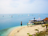
Long Key (ou Rattlesnake key) (Florida Keys)
9.5nm
177°
In the early 20th century, Long
Key was the site of a luxurious fishing resort that ...
5 Apr 10
Joëlle
| Latitude | Longitude | |
| DMS | --- | --- |
| DM | --- | --- |
| DD | --- | --- |


Ebook | Gulf of Mexico
|
 Florida Bay is an estuary covering approximately 1,100 square miles (2,850 square km) between the southern tip of Florida and the Florida Keys,from Barnes Sound to cape Sable. It is located on a shallow shelf lagoon where freshwater from the Everglades mixes with the saltwater from the Gulf of Mexico. Inflow of fresh water into Florida Bay occurs through sheet flow across the southern Everglades. However, water management practices have drastically altered the flow through the construction of canals, resulting in a 50% reduction of freshwater input over the past century.
Dominant habitats in the Florida Bay include seagrass meadows, mangrove islands, and hard bottom areas.
Depths are shallow and irregular; the bottom is mostly mud. From April to October the waters of the bay are clear and the shoals plainly discernible, but during the winter the water frequently turns milky and renders the shoals indistinguishable.
Only small craft can navigate this part of the bay which is frequented by small motor yachts, crab and lobster fishermen, and other fishing craft.
A protected area of the Everglades National Park is in the northern part of Florida Bay. Landing on the beaches or keys of this area without the authorization of the Superintendent of the Everglades National Park is prohibited, except on those beaches or keys marked by a sign denoting the area as being open. Everglades National Park is a Marine Protected Area.
In the E part of the bay are small keys and numerous mudflats which bare, or nearly bare, at low water.
The W part of the bay has depths ranging from 7 to 13 feet, and the bottom is covered with loggerhead sponges and turtle grass.
For the protection of wildlife, all keys in the Florida Bay portion of Everglades National Park are closed to landing except those marked as designated camping areas.
The killing, collecting, or molesting of animals, the collecting of plants, and waterskiing are prohibited by Federal Regulation.
 La Baie de Floride est un estuaire couvrant environ 1.100 miles carrés (2.850 kilomètres carrés) entre la pointe sud de la Floride et les Keys de Floride, entre Barnes Sound et Cape Sable. Elle est située sur un lagon peu profond, plateau où l'eau douce des Everglades se mélange à l'eau salée du golfe du Mexique. L'afflux d'eau douce dans la
Les profondeurs sont peu profondes et irrégulières; le fond est surtout boueux. D'avril à Octobre les eaux de la baie sont claires et les écueils sont clairement visibles, mais pendant l'hiver l'eau se transforme, elle est souvent laiteuse et rend les bancs indiscernables.
Seules les petites embarcations peuvent naviguer dans cette partie de la baie qui est fréquentée par des
petits yachts à moteur, les pêcheurs de homard, et les bateaux de pêche.
Beaucoup de hauts fonds avec des profondeurs moindres sont dispersés dans toute cette partie de la baie; Le fond est recouvert d'éponges panier et de petites têtes de corail.
La partie nord de la baie de Floride est une zone protégée du Parc national des Everglades. L'atterrissage sur les plages ou des clefs de ce domaine sans l'autorisation du surintendant du Parc national des Everglades est interdite, sauf sur celles des plages ou des touches marquées par un panneau indiquant la zone comme étant ouvertes. Everglades National
Park est une zone de protection marine.
La partie
Ouest de la baie a des profondeurs allant de 2,1 m à 4,8 m, et le fond est recouvert de caouanne, d'éponges et d'herbes à tortue.
Pour la protection de la faune, toutes les touches dans la partie de la baie de Floride du Parc national des Everglades sont fermées à l'atterrissage, sauf celles marquées comme des aires de camping désignés.
Le meurtre, la collecte, ou la maltraitance des animaux, la cueillette de plantes, et le ski nautique sont interdits par la réglementation fédérale.