Biscayne National Park (Florida)

Biscayne National Park (Florida)

To precisely geolocate this site. Update if necessary.

Localisation

Biscayne National Park (Florida)
LatitudeLongitude
DMS------
DM------
DD------

Characteristics

Coast

Description

Biscayne National Park, a protected area, is between Mile
1097.0 and Mile 1119.2. The National Park Service has established an anchorage area off the northern end of Elliott Key, opposite Mile
1110.0. The anchorage is marked by buoys. A park ranger is stationed at
Elliott Key Harbor opposite Mile 1112.4. Berths and camp sites are available. No services are available.

The park, located just 21 miles east of Everglades National Park, was established as a national monument in 1968. In 1980 it was enlarged to
181,500 acres and designated as a national park to protect a rare combination of terrestrial and undersea life, to preserve a scenic subtropical setting, and to provide an outstanding spot for recreation and relaxation.
It contains well-sheltered section of Biscayne Bay, about 45 low islands, called "keys," and about 20 miles of mainland mangrove shoreline.

Sea turtles are common in Biscayne Bay, feeding on the sea grasses on the shallow bay bottom.
Today, there is some harvesting of sponges is limited and the price of natural sponges has greatly increased.

At the center of Biscayne National Park are the coral reefs. Unlike the ocean depths, which are dark and nearly lifeless, the shallow water reefs are inundated with light and burgeoning with life. Brilliantly colorful tropical fish and other curious creatures populate the reefs.

The keys can be reached only by boat. Developed recreation areas and services are limited to a few islands. Boat fuel, supplies and food are not available on any island but are available at mainland marinas.
Only Elliott Key has drinking water.

2010/04/18
Update
Joëlle
Biscayne National Park (Florida)
2010-04-18
Update
Joëlle
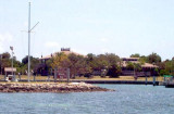
Biscayne National Park, une zone protégée, se trouve entre le point milliaire 1097,0 et le point milliaire 1119,2. Le National Park Service a établi une zone de mouillage au large de la pointe nord de Elliott Key, en face de Mile 1110,0. L'ancrage est marqué par des bouées.
Un gardien de parc est stationné à
Elliott
Key en face du port Mile 1112,4. Les points de mouillage et les terrains de camping sont disponibles. Aucun service n'est disponible.

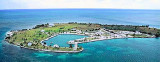
Le parc, situé à seulement 21 miles à l'est du Parc national des
Everglades, a été créé comme un monument national en 1968. En 1980, il a été élargi à 181.500 hectares et désigné comme un parc national pour protéger une rare combinaison de la vie terrestre et marin, et préserver un cadre pittoresque subtropicale, ainsi que de fournir un emplacement privilégié pour les loisirs et la détente.

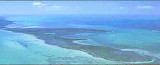
C'est la zone bien abritée de la baie de Biscayne, avec environ 45 îles basses, appelées «clés», et avec environ 20 miles de côte continentale en mangrove.

Les tortues de mer sont courantes dans la baie de Biscayne, se nourrissant d'algue sur le fond de la baie peu profonde.
Aujourd'hui, la récolte d'éponges est limitée et le prix des éponges naturelles a considérablement augmenté.

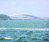
Les touches ne sont accessibles que par bateau. Les aires de loisirs et les services sont limitées à quelques îles. Bateau de carburant, fournitures et denrées alimentaires ne sont pas disponibles sur toute l'île, mais sont disponibles dans les marinas du continent. Seuls Elliott Key a l'eau potable.

Les récifs coralliens sont au centre du Parc national de Biscayne . Contrairement aux profondeurs de l'océan, qui est sombre et presque sans vie, les récifs des eaux peu profondes sont inondés de lumière et en plein essor avec la vie. Des poissons colorés tropicaux et autres créatures bizarres peuplent les récifs.

2012/04/16
Update
JB
Ebook

Gulf of Mexico

  • 227 sites
  • 182 photos
  • publication date: 9 Jul 2023
  • .pdf file size: 78 Mb
Share your comments or photos on "Biscayne National Park (Florida)"

Sites around Biscayne National Park (Florida)

Flying distances - Direct line

Elliot Key (Florida)

2.3nm
202°
Elliott Key is the northernmost of the true Florida
Keys (those 'keys' which are ancient coral reefs lifted above the present sea level), and the largest key north of Key
Largo. It is located entirely within Biscayne National Park.
It is bordered by the Atlantic Ocean to ...
18 Apr 10
Joëlle

Key Biscayne (Miami)

13nm
Key Biscayne is an island located in Miami-Dade County, Florida, United States, between the Atlantic Ocean and Biscayne
Bay. It is the southernmost of the barrier islands along the Atlantic coast of Florida, and lies south of Miami Beach and southeast of Miami. The Key is connected ...
18 Apr 12
JB

Sands Key (Biscayne NP)

1.8nm
11°
Sands Key is an island north of the upper Florida
Keys in Biscayne National Park.It is located in lower Biscayne
Bay, between Elliott Key and Boca Chita Key.
19 Apr 10
Joëlle

Miami Beach (Florida)

21nm
Miami Beach occupies the barrier beach that separates the ocean from the upper part of Biscayne Bay and is also an important yachting center. A number of causeways, with bridges over the channels, form good highway connections with Miami and the mainland communities.
The city is ...
8 Apr 10
Joëlle

Elliot Key Harbor (Biscayne NP)

1.4nm
197°
The entrance at Elliott Key harbor is approximately 2 ½ feet at low tide. Low tide is calculated by adding three hours and twenty-five minutes to the low tide at Miami's Government Cut. High tide is calculated by adding two hours and twenty-eight minutes to the high tide at Government ...
18 Apr 10
Joëlle

Boca Chita Key (Key Biscayne)

2.8nm
14°
Boca Chita is a small island that is located approximately 12 miles south of the Cape Florida lighthouse on Key
Biscayne, and Boca Chita Key is located approximately
9 miles from Convoy Point.
WARNING!!! ---
MOSQUITOES
ARE REALLY BAD OVER SUMMER MONTHS!
At one point, ...
15 Apr 10
Joëlle