Whether you are fishing, cruising, or diving, we are most conveniently located on Tavernier Creek, with easy access to the Atlantic Ocean and Florida Bay.
On the Bayside, Flashing Green # 71 On the Oceanside, Black & White flashing buoy.
Tel: 305-852-5854 Fax:305-852-7425 Email: tavcrkmar@live.com Minimum depth on the entrance: 3 feet (Low tide) and 5 feet (high tide).
2010/03/27
Update
JB
Que vous soyez à la pêche, de croisière ou de plongée, nous sommes le plus idéalement situé sur Tavernier Creek, avec un accès facile à l'océan Atlantique et la Baie de Floride. Du côté de la baie, clignotant vert # 71, du côté de l'océan, bouées clignotantes noire & blanche.
Tel: 305-852-5854 Fax:305-852-7425 Email: tavcrkmar@live.com Profondeur minimum à l'entrée: 0,9 m (marée basse) et 1,5 m (marée haute).
Long Key was called Cayo Vivora (Rattlesnake Key) by early Spanish explorers, a reference to the shape of the island, which resembles a snake with its jaws open, rather than to its denizens. In the early 20th century, Long Key was the site of a luxurious fishing resort that ...
The first underwater park in the U.S., John Pennekamp Coral Reef State Park encompasses approximately 70 nautical square miles. It is the coral reefs and their associated marine life that bring most visitors to the park. Many enjoy the view of the reef from a glass-bottom ...
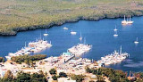
Mangrove Marina is located on Key Largo, at ICW marker #65 and between day markers #1 and #2.130 slips with 15 transients (<65 feet) Reservations are preferred. Tel - (305) 852-8380 Fax - (305) 852-9466 Email - mangrove@terranova.net
The island lies to the southwest of Upper Matecumbe Key, and to the northeast of Craig Key. All of the key is within the Village of Islamorada as of November 4, 1997, when it was incorporated. This key is the site of a number of Indian mounds and middens, most of which were ...
Blue Waters Marina is located in Tavernier just minutes off the Atlantic Ocean in the Florida Keys. Blue Waters Marina is just 50 miles north of Marathon and 93 miles north of Key West. The marina is located approx. 60 nautical miles south of the Government ...
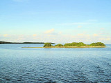
Rodriguez Key is a nearshore mangrove island surrounded by a shallow mud bank. A branching-coral and coralline-algae zone protects the muddy surface and mangroves of the island.Northern anchorage is possible only when the weather is fair.


 Whether you are fishing, cruising, or diving, we are most conveniently located on Tavernier Creek, with easy access to the Atlantic Ocean and
 Que vous soyez à la pêche, de croisière ou de plongée, nous sommes le plus idéalement situé sur Tavernier Creek, avec un accès facile à l'océan Atlantique et la
")
")