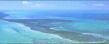
The first underwater park in the U.S., John Pennekamp Coral Reef State Park encompasses approximately 70 nautical square miles. It is the coral reefs and their associated marine life that bring most visitors to the park. Many enjoy the view of the reef from a glass-bottom boat tour, but visitors can get a closer look by scuba diving or snorkeling. Canoeing and kayaking through the park's waters are popular activities; fishing is permitted in designated areas. Visitors can enjoy walking on short trails, picnicking, or swimming at the beach.
Tel: (850) 245-2157
2010/03/31
Update
Joëlle
John Pennekamp Coral Reef State Park (Key Larg
2010-03-31
Update
Joëlle
Le premier parc sous-marin aux États-Unis, John Pennekamp Coral Reef State Park englobe environ 70 miles nautiques carrés (130 km²). Il s'agit de récifs coralliens et de leur vie marine associée qui apportent de nombreux visiteurs sur le parc. Certains peuvent voir le récif au cours d'une excursion en bateau à fond de verre, mais d'autres peuvent voir de plus près en plongée sous-marine ou en apnée. Le Canoë-kayak dans les eaux du parc est une activité populaire, la pêche est autorisée dans les zones désignées. Les visiteurs peuvent apprécier la marche sur les sentiers, le pique-nique, ou la baignade à la plage.
Elliott Key is the northernmost of the true Florida Keys (those 'keys' which are ancient coral reefs lifted above the present sea level), and the largest key north of Key Largo. It is located entirely within Biscayne National Park. It is bordered by the Atlantic Ocean to ...
Key Largo Dry Rocks lies within the boundaries of the previous Key Largo National Marine Sanctuary.Key Largo Dry Rocks is located seaward of White Banks and extends to an approximate depth of 30 feet. Dry Rocks SPA covers an area of approximately 0.05nm2, or about 16ha, and ...
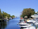
From the Ocean take Hawks Channel to Red Marker Number 32. From Marker go to the sunken barge and follow the Channel to Channel Marker Green 19 and turn right into Garden Cove Canal. The marina is at the end of canal. Garden Cove Marina is on a saltwater canal providing access to ...
In the Key Largo Area are Mosquito Banks, at a short distance from the Pennekamp Coral Reef State Park. Mosquito Bank overlies a concave low-elevation indentation or reentrant in the bedrock depression beneath Hawk Channel. Sediments in Mosquito Bank are mostly muddy sands with ...
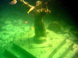
Christ of the Abyss is a 8 1/2 foot, 4,000 pound bronze sculpture of Jesus Christ that stands in 25 feet of water off of Key Largo, Florida. It is located near Dry Rocks, about six miles east-northeast of the Key Largo Cut, in the John Pennekamp Coral Reef State Park. This ...
Long Key was called Cayo Vivora (Rattlesnake Key) by early Spanish explorers, a reference to the shape of the island, which resembles a snake with its jaws open, rather than to its denizens. In the early 20th century, Long Key was the site of a luxurious fishing resort that ...


")