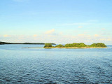
Long Key (ou Rattlesnake key) (Florida Keys)
18nm
234°
In the early 20th century, Long
Key was the site of a luxurious fishing resort that ...
5 Apr 10
Joëlle
| Latitude | Longitude | |
| DMS | --- | --- |
| DM | --- | --- |
| DD | --- | --- |


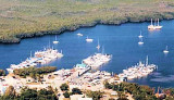
 Blue Waters Marina
The marina is located approx. 60 nautical miles south of the Government Cut
entrance at Miami, Via Hawks Channel. From the red #2 light at Tavernier
Key (N25 degrees 00.20 W80 degrees. 98) proceed straight west 270
degrees) to the red #4 light. Bear right on a course of 030 degrees
to our entrance canal at N25 degrees 00.75 W80 degrees
30.30.
The canal is narrow, but as you near the end a large turning
basin will appear to your left. Blue Waters Marina is located on the
northwest corner of this twenty foot deep basin.
Tel: (305) 853 5604
Mail: jerry@bluewatersmarina.com
Depth: 7 feet (low tide), 8 to 9 feet (High tide)
")
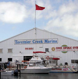
 Blue Waters Marina est située à Tavernier, à quelques minutes de l'Océan Atlantique dans les Florida Keys. Blue Waters Marina est juste à 50 miles au N de Marathon et 93 miles au N de Key West.
La marina se trouve approximativement à 60 MN au S de l'entrée de Miami, en passant par Hawks Channel. Au fey rouge #2 de Tavernier Key (N25 degrees 00.20 W80 degrees. 98) faire un 270 degré à l'W vers le feu rouge#4. Virer à droite sur un cap au 030 degré vers le canal d'entrée des degrés N25 00,75 W80 30,30.
Le canal est étroit, mais près de la fin un grand bassin d'évitage apparaîtra sur gauche. Blue Water Marina est située au coin NW de ce bassin de 6 m.
Tel: (305) 853 5604
Mail: jerry@bluewatersmarina.com
Profondeur: 2,1 m (marrée basse), 2,4 à 2,7 m (Marrée haute)
Ebook | Gulf of Mexico
|