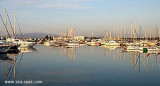
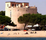
Correct anchorage in front of the beach (3/6 m), but very noisy, nightclub on the beach (I was anchored in front!), move away a little and not worry.
2012/11/8
Update
17 Jan 2010 17:58
:
Mouillage correct devant la plage (3/6 m), mais très bruyant, discothèque de plage, (j'étais ancré juste devant!) s'éloigner un peu et pas de souci.
2012/11/8
Update
Ancoraggio coretto davanti alla spiaggia (3/6 m), ma la discoteca dalla spiaggia è molto rumoroso (era ancorato di fronte!), andate fuori un poco e non preoccupatevi.
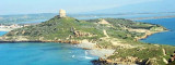
The Aragonese Tower of Torregrande (15 m high) is surrounded by houses. A light is at the top.
It was built on the orders of the Spanish Viceroy Charles V (1537), originally called Tower "puerto de Oristan" (1639), only age Savoy had its current name: "Grande de Oristan" Tower ...
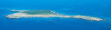
Mal di Ventre island takes its name the difficulties encountered by sailors to navigate its waters. Located opposite the Peninsula del Sunis, low and flat, 18 m high, it has an area of 80 hectares. A light is shown from a structure, 4m high, standing on the summit of the ...
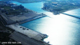
Large commercial harbour in the center of the W coast of Sardinia, S Tirso river. Within the commercial harbor is a marina.To access run through the channel dredged to 13 m, marked by two luminous beacons. Tel: 0783 72262 Fax: 0783 359933 E-mail: oristano@guardiacostiera.it
The Phoenicians settled in Tharros to 800 BC, then came the turn of the Carthaginians in 500 BC. Port Tharros became a place of passage and a strong center of commercial activity. Its privileged position within the Sinis peninsula, protected from the mistral, the fertility ...


 Correct anchorage in front of the beach (3/6 m), but very noisy, nightclub on the beach (I was anchored in front!), move away a little and not worry.
 17 Jan 2010 17:58
:
17 Jan 2010 17:58
: Ancoraggio coretto davanti alla spiaggia (3/6 m), ma la discoteca dalla spiaggia è molto rumoroso (era ancorato di fronte!), andate fuori un poco e non preoccupatevi.
")
")