It is the largest island of the archipelago composed of sixty islets and 7 major islands, in the NE end tip of Sardinia. It is mountainous and arid. This is the only inhabited island thoroughly. It is connected by a bridge to Caprera island where are the house and the tomb of Garibaldi. ...
Gulf of Arzachena (Arsachena), located between Punta Saline and Tre Monti Cape, is a high inlet whose banks are lined with shoals. S tip, Arzachena, W of the entrance, a beacon consists of an iron post with a sheer spherical white marks a rock particularly ...
La tourelle Pecorella marque l'entrée de ce golfe qui s'enfonce à plus de 4 M dans les terres. Celle de Chiapino qui était plus au S est démolie. Il faut donc remonter suffisamment vers le N pour ne pas risquer d'en toucher les restes. En piquant vers l'W, la balise noire délimite ...
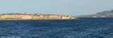
Tavolara island is a limestone massif 6 kilometres long and 500 m wide, and 565 m high.The overhanging cliffs make it inaccessible, with the exception of a bay and a beach that is located at each end of the island, Spalmatore di Fuori northeast (military zone) and Spalmatore di Terra ...
Located E of Cape Tre Monti, just before Battistone cape. Sardinia Bay or cala di Battistone has a military mole in the center that allows docking twenty boats and anchoragio during the day.


 The shoal Tre Monti is located approximately 3/4 miles N of Capo Tre Monti.
 Le haut-fond de Tre Monti est situé à près de 3/4 de milles au N de Capo Tre Monti.
 La secca di Tre Monti è a circa 3/4 di miles N capo Tre Monti.