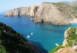
Pan di zucchero cliff is the most remarkable of small islands that are found in this part of the Sardinian coast.
Pan di Zucchero, rock 133 m high, is located opposite the Masua beach and short distance E of Porto Flavia.
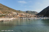
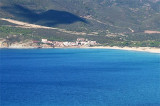
The small beach Masua is made of white sand rising from the rocks next to the limestone which also opens the entrance to the mine Porto Flavia.
2012/11/6
Update
Le rocher Pan di Zucchero est le plus remarquable des petits îlots que l'on trouve dans cette partie de la côte sarde.
Le Pan di Zucchero, rocher haut de 133 m, se trouve en face de la plage de Masua et à peu de distance à l'E de Porto Flavia.
La petite plage de Masua est faite de sable blanc surgissant des rochers, à côté du massif calcaire où s'ouvre aussi l'entrée de la mine de Porto Flavia.
2012/11/6
Update
Il faraglione di Pan di Zucchero, alto 133 m, si trova di fronte la spiaggia di Masua e a poche centinaia, a E, di Porto Flavia. La spiaggia du Masua è una piccola striscia di sabbia bianca incatonato nelle roccia, acanto al massicio calcareo dove si apre anche l'entrata della miniera di Porto Flavia.
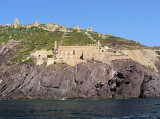
Porto Flavia is an abandoned mine site since recent decades. Minerals came from Masua, long galleries allowed to carry in the rocky walls and ended directly in the holds of merchant ships moored under the rock wall. Porto Flavia was used for the shipping of minerals.Mining ceased ...
Lamarmora laundry, situated in a unique location and picturesque on the Nebida coast, was built in 1897 by the "Société anonyme Nebida."Its realization with sea view was necessary to facilitate the transport of minerals from the place of extraction of the peninsula, and have on ...
Behind Rama tip is a small deep bay which ends with a sandy beach. It is very picturesque and protected from S winds, but dangerously exposed to the Mistral.
If time permits, you can anchor in the cove splendid.
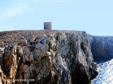
Rama tip, 300 m high, limit, to the W, the small cove Domestica, narrow and rocky.It has a tower that used to guard the cove Domestica entrance where was a small port to embark minerals from various mines in the area.
Small marina located in the large Portixeddu bay tra Punta S. Nicolo e Capo Pecora. It is the only possible stop between Carloforte and Oristano. It is in Buggarru town.The Port is limited to yachts with shallow draft. The entrance and funds within the port are especially low because ...


")
") Masua beach
Masua beach
")