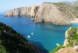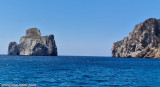

Scoglio Pan di Zucchero (Sardegna)
0.4nm
245°
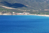
Pan di Zucchero, rock 133 m high, is located opposite the Masua beach and short distance E of Porto Flavia.
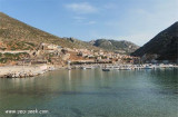
The small beach Masua is made of white ...
6 Nov 12
| Latitude | Longitude | |
| DMS | --- | --- |
| DM | --- | --- |
| DD | --- | --- |


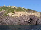
 Porto Flavia is an abandoned mine site since recent decades.
Minerals came from Masua, long galleries allowed to carry in the rocky walls and ended directly in the holds of merchant ships moored under the rock wall. Porto Flavia was used for the shipping of minerals.
Mining ceased permanently in 1991, however, the installation will remain active until the end of 1997.
Porto Flavia is an ingenious structure that has revolutionized the system of boarding minerals. A receiving conveyor receiving minerals from underground deposits to transfer, with its ingenious movable arm, directly into the hold of the transport ships at anchor, on buoys by 9 m deep.
You can anchor in 9 m, close to the loading facility or moor to the numerous mooring buoys in the vicinity.
It is sheltered from N wind.
")
 Porto Flavia est un site minier abandonné depuis quelques décennies.
Les minéraux provenaient de Masua, de longues galeries permettaient de les transporter sous la parois rocheuse et finissaient directement dans les cales des navires marchands amarrés sous la paroi rocheuse. Porto Flavia était utilisé pour l'expédition des minerais.
L'activité minière cessa définitivement dans les années 1991, cependant l'installation restera active jusqu'à la fin 1997.
On peut ancrer par 9 m près l'installation de chargement ou à l'une des nombreuses bouées de mouillage situées dans ce secteur.
Protégé du vent du N.
") Pan di Zucchero in front of Porto Flavia
Pan di Zucchero in front of Porto Flavia Porto Flavia è uno sito mineraro abandonato da moliti decenni.
Il minerale proveniva da Masua attraverso lunghe gallerie e andava a finire direttamente nelle stive dei mercantili, ormeggiati sotto la parete rocciosa. Porto Flavia era usato per la spedizione del minerale.
L'attività mineraria cessava definitivamente nell'anno 1991, mentre gli impianti restarono attivi fino al 1997.
Porto Flavia è un ingeniosa struttura che ha rivoluzionato il sistema di imbarco dei minerali. Un nastro trasportatore riceveva i minerali dai depositi sotterranei per trasferirli, con il suo ingegnoso braccio mobile, direttamente nella stiva delle navi da carico alla fonda, su boe, in fondali di 9 m.
Si puo ancorare in 9 m, in prossimità della struttura di carico o ormeggiare alle numerose boe nelle vicinanze.
Si è al riparo dal vento N.
Ebook | Sardegna West
|