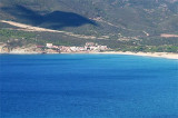
Small marina located in the large Portixeddu bay tra Punta S. Nicolo e Capo Pecora. It is the only possible stop between Carloforte and Oristano. It is in Buggarru town.
The Port is limited to yachts with shallow draft. The entrance and funds within the port are especially low because of silting. The entrance is difficult with W winds.
350 b. (<12 m)
Tel.+39.078.183071
Draugh: 1/3 m
2012/11/7
Update
Petit port situé dans la grande baie de Portixeddu entre Punta S. Nicolo et Capo Pecora. C'est l'unique escale possible entre Carloforte et Oristano. Il est situé dans la ville de Buggerru.
Le Port est limité aux yachts à faible tirant d'eau. L'entrée et les fonds à l'intérieur du port sont spécialement bas à cause de l'ensablement. L'entrée est difficile par vents d'W.
350 places (<12 m)
Tel.+39.078.183071
Profondeur: 1/3 m
2012/11/7
Update
Porticciolo situato nella granda baia di Portixeddu tra Punta S. Nicolo e Capo Pecora. E' l'unico scalo possibile tra Carloforte e Oristano. E' in paese.
Il porto è limitato ai picoli diporti. L'l'ingresso e i fondali all'interno sono spesso bassi a causa di insabbiamenti. L'ingresso è pericolosa con venti del IV quadrante.
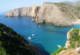
Behind Rama tip is a small deep bay which ends with a sandy beach. It is very picturesque and protected from S winds, but dangerously exposed to the Mistral.
If time permits, you can anchor in the cove splendid.
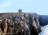
Rama tip, 300 m high, limit, to the W, the small cove Domestica, narrow and rocky.It has a tower that used to guard the cove Domestica entrance where was a small port to embark minerals from various mines in the area.
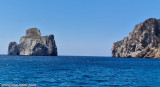
Pecora cape is a small projection, 18 m high, wich is joined to the coast by a low tretch of land. It is dominated 1,3 NM to E by "del Gaurdiano" tip (478 m high).It is shaped by the constant action of water and Mistral.An above-water rock is W of the cape.Between Pecora cape and ...
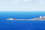
Porto Flavia is an abandoned mine site since recent decades. Minerals came from Masua, long galleries allowed to carry in the rocky walls and ended directly in the holds of merchant ships moored under the rock wall. Porto Flavia was used for the shipping of minerals.Mining ceased ...


 tenue médiocre
 tenue médiocre
 canal 16


 Small marina located in the large Portixeddu bay tra Punta S. Nicolo e Capo Pecora. It is the only possible stop between Carloforte and Oristano. It is in Buggarru town.
 Petit port situé dans la grande baie de Portixeddu entre Punta S. Nicolo et Capo Pecora. C'est l'unique escale possible entre Carloforte et Oristano. Il est situé dans la ville de Buggerru.
 Porticciolo situato nella granda baia di Portixeddu tra Punta S. Nicolo e Capo Pecora. E' l'unico scalo possibile tra Carloforte e Oristano. E' in paese.
")
")
")
")