Rügen

Rügen

To precisely geolocate this site. Update if necessary.

Localisation

Rügen
LatitudeLongitude
DMS------
DM------
DD------

Characteristics

Island / Atoll

Description

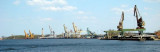
Rügen is the largest island of Germany with over twelve “Bodden” (lagoon-like waters) connected up to each other by small bays. West winds dominate and high seas have to be expected.
2014/06/26
Update
Ebook

Baltic sea

  • 84 sites
  • 71 photos
  • publication date: 11 Jul 2023
  • .pdf file size: 70 Mb
Share your comments or photos on "Rügen"

Sites around Rügen

Flying distances - Direct line

Stralsund

14nm
226°
Small port protected by a breakwater.
30 Jul 11
MaddeOchHenny

Trelleborg

53nm
350°
Port protected by a breakwater.
29 Jul 11
iansilv

Moen - DK

40nm
313°
Moen Lighthouse
With a growing traffic in the middle of the 1800s increased the need for demarcation of the Danish coasts. In 1845 the lighthouse was the maid garnish turned south and followed a few years after the lighthouse on Dasser Ort in Mecklenburg coast. The 13 meter high ...
15 Dec 09
holger

Ystad Marina

58nm
14°
Port protected by a breakwater.
29 Jul 11
evilgusgus

Port Świnoujście

45nm
138°
For the approach use the navigation channel:- 32Nm long
- width 180m
- depth 14mThe port can accomodate ships of up to 270m long.The port is ice free.
27 Jun 14
DD06

Świnoujście Marina

45nm
138°
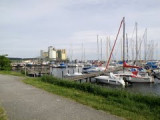
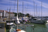
The marina is a modern yacht harbour with 200 berths and comfortable equipment.  Access You must expect currents in the mouth of the Swine, which may even put you off course when the wind blows from the west.
26 Jun 14