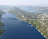
Rt Nedjelja is the NW extremity of a tongue of land which extends 0.9 mile NW from the N side of Poluotok Peljesac. Kanal Malog Stona becomes constricted and shallow SE of this point and can only be used by small craft with local knowledge.
Sheltered anchorage can be taken, in depths of 22 to 25m, mud, anywhere under the N shore of Kanal Malog Stona in its outer part.
2011/05/1
Update
Jojo
Rt Nedjelja est l'extrémité nord-ouest d'une langue de terre qui s'étend à 0.9 mile au NW du côté N de Poluotok Peljesac. Kanal Malog Stona devient resserré et peu profond au SE de ce point et ne peut être utilisé que par de petites embarcations avec des connaissances locales. On y trouve un mouillage abrité, à des profondeurs de 22 à 25m, sur fond de boue, partout du côté de la rive nord du Kanal Malog Stona dans sa partie extérieure.
It is the largest and most populated island of the group Elafiten. It rises to 234 m at its N and a prominent hill rises 224 m NW of the SE end. Ruda is a small island that is 0.5 M SE of the NE extremity of the island and Misnjaka, 13 m high, lies close off the NW extremity. ...
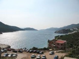
Stonski Kanal, a deep inlet, indents the SE end of Poluotok Peljesac at the NW end of Kolocepski Kanal. Its shore rises rapidly on each side and provides protection from NE and SW winds. The village of Brocej is situated on the S shore 3.8 miles within the entrance. It is fronted ...
The narrow sea from Zaliv Klek Neum is 4 NM long and lies at the NE channel Malog Stone. It is surrounded by mountains and is inserted between Rt Rep Kleka and Rt Meded. Depths exceeding 20 meters in most cases. There are several anchorages. The SE part and W peninsula ...
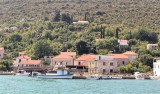
NW of Hodilje, Luka is a small hamlet with repair yards of fishing boats. You can anchor in the middle of the creek by 3 m. Funds back to 1.5 m near the wharf.
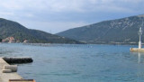
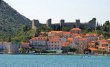
This small town is near the end of Kanal Malog Stone, on the Peljesac peninsula. The channel leading to Mali Ston has several areas of rocks and shoals on either side, but it is well marked with lights. There are at least 3 m depth in the channel. A small town bordering the ...


 Rt Nedjelja is the NW extremity of a tongue of land which extends 0.9 mile NW from the N side of Poluotok Peljesac.
 Rt Nedjelja est l'extrémité nord-ouest d'une langue de terre qui s'étend à 0.9 mile au NW du côté N de Poluotok Peljesac.