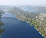
Luka Mali Ston Peljesac

Luka Mali Ston Peljesac

To precisely geolocate this site. Update if necessary.

Localisation

Characteristics

Port
Mud
Mooring
Water à Ston
Phone
Fuel à 4,5 km
Market à Ston
Restaurant
Post

Description

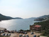
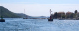
This small town is near the end of Kanal Malog Stone, on the Peljesac peninsula.
The channel leading to Mali Ston has several areas of rocks and shoals on either side, but it is well marked with lights. There are at least 3 m depth in the channel.
A small town bordering the port at the bottom of the bay.
Can moor at the wharf near the tower by 2 to 2.5 m, attention inside the dock is unhealthy.
We can anchor in the harbor by 4 m.
Good protection.
The port was built on the model of the old port of Dubrovnik galley, with three arsenals for warships.
2011/05/1
Update
Jojo
Luka Mali Ston Peljesac
2011-05-01
Update
Jojo
Cette petite ville se trouve près de l'extrémité du Kanal Malog Stona, sur la péninsule de Peljesac.

Le chenal menant à Mali Ston a plusieurs rochers et zones de hauts-fonds de chaque côté, mais il est bien balisé avec des feux. Il y a au moins 3 m de fond dans le chenal.

Un petit port borde la petite ville, au fond de la baie.

On peut s'amarrer au quai près de la tour par 2 à 2,5 m, attention l'intérieur du quai est malsain.
On peut mouiller au N du port par 4 m.

Bonne protection.

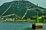
Le port a été construit sur le modèle du vieux port des galères de Dubrovnik, avec trois arsenaux pour les navires de guerre.

2011/05/1
Update
Jojo
Luka Mali Ston Peljesac
2011-05-01
Update
Jojo
Luka Mali Ston Peljesac
2011-05-01
Update
Jojo
Ebook

Dubrovačko-neretvanska županija (Dubrovnik–Neretva

  • 138 sites
  • 228 photos
  • publication date: 9 Jul 2023
  • .pdf file size: 74 Mb
Share your comments or photos on "Luka Mali Ston Peljesac"

Sites around Luka Mali Ston Peljesac

Flying distances - Direct line

Otok Sipan

10nm
132°
It is the largest and most populated island of the group Elafiten. It rises to 234 m at its N and a prominent hill rises 224 m NW of the SE end.
Ruda is a small island that is 0.5 M SE of the NE extremity of the island and Misnjaka, 13 m high, lies close off the NW extremity.
...
16 Apr 11
Jojo

Stonski Kanal

2.9nm
149°
Stonski Kanal, a deep inlet, indents the SE end of Poluotok Peljesac at the NW end of Kolocepski Kanal.
Its shore rises rapidly on each side and provides protection from NE and SW winds. The village of Brocej is situated on the S shore 3.8 miles within the entrance.
It is fronted ...
25 Apr 11
Jojo

Zaliv Klek Neum

7.1nm
311°
The narrow sea from Zaliv Klek Neum is 4 NM long and lies at the NE channel Malog Stone. It is surrounded by mountains and is inserted between Rt Rep Kleka and Rt Meded.
Depths exceeding 20 meters in most cases. There are several anchorages.
The SE part and W peninsula ...
3 May 11
Jojo

Ston Stonski Kanal

0.8nm
201°
The little town lies at the bottom of Stonski Kanal.
The channel from Broce to Ston is marked by five red lights at Port and 2 green lights to starboard. Warning to a submerged obstruction to about 70 m NNW of the end of the pier Broce, you have to go to the end of the pier to ...
26 Apr 11
Jojo

Luka Hodilje Peljesac

0.9nm
311°
Hodilje is on the SW bank of the fairway, 1 M NW of Mali Ston.
We moored alongside the pier, inside by 3 m.
You can anchor at N by 9 m.
30 Apr 11
Jojo

Broce Stonski Kanal

1.5nm
162°
Broce is a small village located at the narrow entrance to the buoyed channel which leads to Ston.
Approaching Broce, channel funds back from 7 to 4 m.
26 Apr 11
Jojo